Challenge yourself to a climb and reap the rewards of splendid views, or take a more leisurely cycle ride through historic villages and delightful countryside.
Use the hashtag #blackdownramble to share and read about walks and rides in the Blackdown Hills.
Hemyock, Uffculme and Culmstock
Download PDFA leisurely ride, with a climb near the start. On your way you’ll see Coldharbour Mill, a yew tree growing out of a church tower, and the beacon house on Culmstock Common. One of eight cycle routes in the Blackdown Hills National Landscape – Route 1
Main route (1 – 17)
1 Turn left out of car park and left just after the Catherine Wheel
2 Turn right at Lickham Cross
3 At crossroads (Leigh Cross) go straight, signposted Leigh
4 At junction turn right
5 At junction turn left
6 At junction turn right, signposted Ashill, Uffculme
7 At junction (cemetery corner) turn left onto main road, signposted Uffculme
8 Turn right at Uffculme just before the Ostler Inn
9 At Penslade Cross go straight over, signposted Penslade
10 At junction turn right
11 At crossroads (Higher Cross) go straight over, signpost Nicholashayne
12 Turn first right
13 At crossroads turn right on to main road, signposted Culmstock
14 Turn left at village hall in Culmstock and then first right by red phone box
15 Turn right at Whitehall Cross, signposted Hemyock
16 At junction turn left, signposted Hemyock
17 Turn right and return to car park
Shorter route – 7 miles (replaces stages 5 – 14)
a At junction turn right, signposted Culmstock
b At junction turn right
c Turn first right after Culm Valley Inn and go through residential area to reach main road
d Turn right onto road
Go to instruction 15
Maps: This route is based on OS Explorer maps and is intended as a guide to cyclists. Refer to Explorer 128 or Landranger 192 and 193 when planning your visit.
General Information: For information about safe cycling and further information to help plan your visit, see www.blackdownhillsaonb.org.uk
Although every effort has been made to ensure the accuracy of the route directions and descriptions, responsibility cannot be accepted for any errors or omissions. If you discover any errors, please let us know.

Hemyock, Blackborough, Broadhembury and Sheldon
Download PDFA moderate to challenging 22-mile ride, with two optional shorter routes. This route takes in a 16th century village, Devon’s finest prehistoric hillfort and evidence of whetstone mining. One of eight cycle routes in the Blackdown Hills National Landscape – Route 2
Main route (1 – 23)
1 Turn left out of the car park and left just after the Catherine Wheel pub
2 Turn right at Lickham Cross
3 At crossroads go straight over, signposted Leigh
4 At junction turn left
5 At junction turn right and then go over ford
6 At junction turn left, signposted Hayne, Bodminscombe, Sheldon and then first right
7 At junction turn left
8 Turn right at Downlands Cross, signposted Kerswell, Cullompton. Just past Knowles Wood car park, take the unsigned road on the left
9 Turn left at Windwhistle Cross
10 At crossroads (Causeway End) turn left, signposted Broadhembury
11 Follow through Broadhembury then turn right at Broadhembury Cross
12 At junction turn left on to main road and left again, signposted Dunkeswell
13 At crossroads (Turbary Cross) go straight over, signposted Blackborough
14 Turn second right at Golden Lane Cross, signposted Sheldon, and follow for 3 miles, passing through Sheldon
15 Turn right, signposted Ashill and follow for 3/4 mile, then turn right signposted to Leigh and go over the ford
16 Turn first left and continue until reaching T-junction
17 At junction turn right, signposted Culmstock
18 At junction with Uffculme Road turn right into village and continue over river
19 Turn first right after Culm Valley Inn into Harts Row, through residential area
20 At junction, turn right
21 Turn right at Whitehall Cross, signposted Hemyock
22 At junction turn left, signposted Hemyock
23 Turn right and return to public car park
Shorter route (A) – 7 miles (replaces stages 4 – 16)
At junction turn right then go to instruction 17
Shorter route (B) – 12 miles (replaces stages 8 – 14)
Turn second left at Golden Lane Cross, signposted Sheldon, then go to instruction 15
Maps: This route is based on OS Explorer maps and is intended as a guide to cyclists. Refer to Explorer 128 or Landranger 192 and 193 when planning your visit.
General Information: For information about safe cycling and further information to help plan your visit, see www.blackdownhillsaonb.org.uk
Although every effort has been made to ensure the accuracy of the route directions and descriptions, responsibility cannot be accepted for any errors or omissions. If you discover any errors, please let us know.

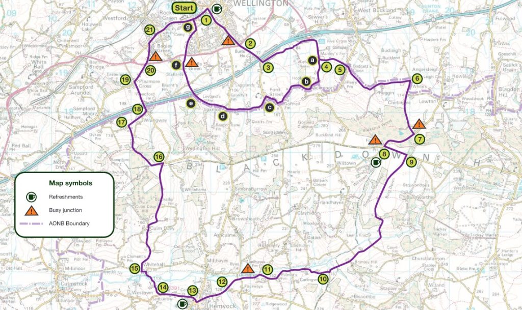
Wellington, Buckland Wood and Hemyock
Download PDFA circular route from Wellington town to Hemyock and back, via Buckland Wood. On bank holidays from April to August you can visit Hemyock Castle too. One of eight cycle routes in the Blackdown Hills National Landscape – Route 3
Main route (1 – 21)
1 Start at Wellington Library, head towards junction with South Street, turn right at lights into South Street, signposted Hemyock, Monument, and follow for nearly one mile
2 At crossroads go straight over, signposted Ford Street
3 Go under the M5 motorway bridge, then turn left, signposted Blackmoor, and follow for one mile
4 Turn left, signposted Ruggin, Pitminster Corfe
5 At staggered junction turn right, then left, signposted Ruggin, Pitminster, Corfe
6 At junction turn right, signposted Lowton, Blagdon, Corfe
7 At junction turn right
8 At junction turn left onto the ridge road, signposted Taunton, Honiton and Chard
9 Turn first right and then follow road for about 2.5 miles
10 At junction (Lilycombe Cross) turn right, signposted Hemyock
11 Straight on to Hemyock
12 Turn right to Hemyock
13 In Hemyock go straight on and follow main road out of village towards Culmstock
14 Turn right at Blackpitt Cross, signposted Whitehall, Culm Davy
15 At junction turn left, then first right, signposted Culm Davy – steep up hill
16 At junction turn left – long down hill
17 At junction turn right
18 At junction turn left onto main road and go over M5 motorway bridge
19 At crossroads turn right, signposted Wellington
20 At staggered junction go straight ahead, signposted Rockwell Green
21 At junction turn right into Wellington and go straight over first set of traffic lights
Shorter route – 4 miles (replaces stages 5 – 21)
An easy ride for all the family with views of the Blackdown Hills
a At junction go straight on
b At junction go straight on
c At junction turn right and take first left signposted Briscoe
d At junction go straight on
e At junction go straight on
f At junction go straight on, taking great care when crossing the busy A38
g At junction turn right
Maps: This route is based on OS Explorer maps and is intended as a guide to cyclists. Refer to Explorer 128 or Landranger 192 and 193 when planning your visit.
General Information: For information about safe cycling and further information to help plan your visit, see www.blackdownhillsaonb.org.uk
Although every effort has been made to ensure the accuracy of the route directions and descriptions, responsibility cannot be accepted for any errors or omissions. If you discover any errors, please let us know.

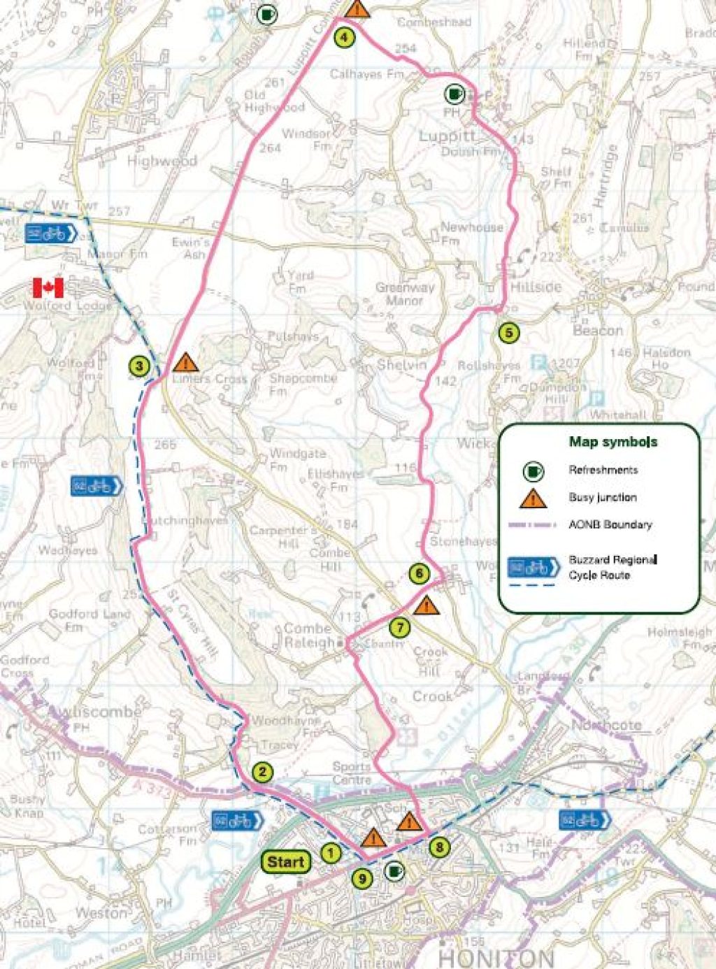
Honiton, Luppitt, and Combe Raleigh
Download PDFA moderate 11-mile ride with challenging uphill and downhill sections, suitable for experienced cyclists with a good level of fitness. Visit Wolford Chapel and Combe Woods along the way. Stop off at St Mary’s Church in Luppitt, to see one of the oldest fonts in Devon. One of eight cycle routes in the Blackdown Hills National Landscape – Route 4.
Main route (1 – 9)
1 With Magistrates Court on left hand side of street (you should be facing away from Honiton
2 Go over road bridge and then turn right at Turnpike Cottage, signposted Egland, and up St Cyres Hill (recommend walking it!)
3 At staggered junction take road ahead, signposted Luppitt, Smeatharpe. (To visit Wolford Chapel turn left and continue along Limers Lane to reach Wolford Lodge, where the Chapel is signed.)
4 Turn right at second crossroads, signposted Luppitt, Beacon
5 Turn right at Barn Cross, signposted Honiton
6 Turn right at Mill Cross, signposted Combe Raleigh
7 At crossroads (Combe Raleigh Cross) go straight over, signposted Combe Raleigh
8 At junction turn right on to Honiton High Street
9 At second set of traffic lights turn right, signposted Cullompton A373 and then the Magistrates Court is on the left-hand side.
Maps: This route is based on OS Explorer maps and is intended as a guide to cyclists. Refer to Explorer 128 or Landranger 192 and 193 when planning your visit.
General Information: For information about safe cycling and further information to help plan your visit, see www.blackdownhillsaonb.org.uk
Although every effort has been made to ensure the accuracy of the route directions and descriptions, responsibility cannot be accepted for any errors or omissions. If you discover any errors, please let us know.

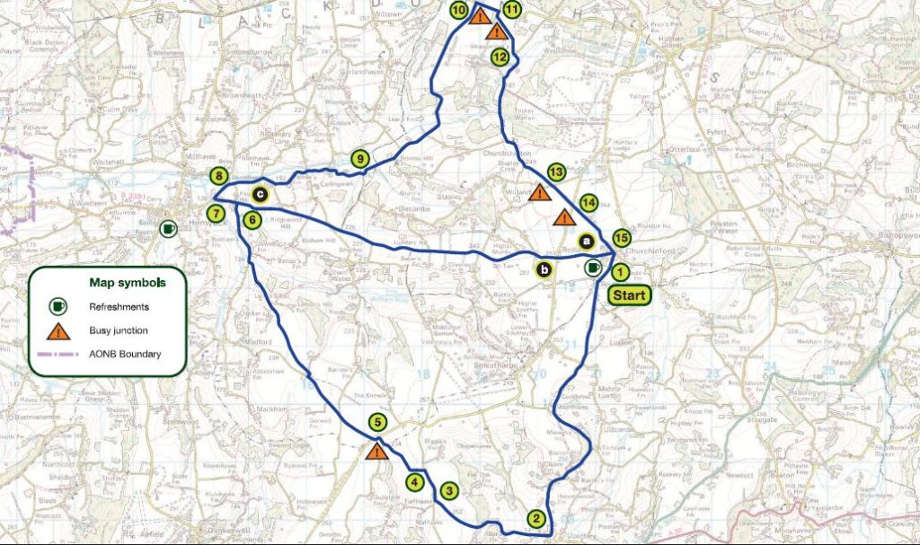
Churchinford, Upottery and Culm Valley
Download PDFA moderate 17.5-mile ride with some challenging uphill and downhill sections on main route, or an optional shorter route of 12 miles. One of eight cycle routes in the Blackdown Hills National Landscape – Route 5.
Main route (1 – 15)
1 Turn left out of the car park and follow road for 4 miles to Upottery
2 In Upottery turn right, signposted Hemyock, 50 metres before the Sidmouth Arms
3 At Mathayes Cross turn right, signposted Hemyock
4 Turn left at Riggles Cross
5 At junction turn left, then right, signposted Madford, Hemyock
6 At crossroads (Fourways Cross) turn left
7 At Culm Bridge turn right (sharp)
8 Take right fork and follow for 1.5 miles
9 Turn left at Lilycombe Cross, signposted Churchstanton
10 At junction turn right on to ridge road
11 Turn first right, signposted Burnworthy
12 At junction turn right, signposted Churchstanton
13 At crossroads go straight over, signposted Churchinford
14 At crossroads go straight over, signposted Churchinford
15 At junction turn left on to main road and then right into car park
Shorter route – 12 miles (replaces stages 1 – 6)
a Turn left out of car park and then right into Red Lane opposite the York Inn
b At crossroads go straight over, signposted Hemyock and follow for nearly 4 miles
c Turn sharp right at Culm Bridge
Go to instruction 8
Maps: This route is based on OS Explorer maps and is intended as a guide to cyclists. Refer to Explorer 128 or Landranger 192 and 193 when planning your visit.
General Information: For information about safe cycling and further information to help plan your visit, see www.blackdownhillsaonb.org.uk
Although every effort has been made to ensure the accuracy of the route directions and descriptions, responsibility cannot be accepted for any errors or omissions. If you discover any errors, please let us know.

Honiton, Stockland and Upottery
Download PDFA challenging 20-mile ride or an optional shorter route of 17 miles. Explore the Blackdown Hills countryside, with its iron-age hill forts. There is a railway station at Honiton, so this is a good ride if you’re planning to access the Blackdown Hills by train. One of eight cycle routes in the Blackdown Hills National Landscape – Route 6.
Main route (1 – 19)
1 Turn left out of the car park and left at traffic lights and follow to the end of the High Street
2 At roundabout turn left, signposted Exeter and London, and then right after 50 metres, signposted Cotleigh, Stockland
3 At top of hill turn right and then left after 50 metres, signposted Cotleigh
4 At junction turn left, signposted Cotleigh, then first right
5 At Stockland Hill, go straight over, signposted Heathstock, Broadhayes
6 Turn right at Shorehead Cross, signposted Heathstock, Ford, Stockland
7 At junction (Ford Cross) turn left, signposted Heathstock, Stockland
8 At junction (Cookers Elm Cross) turn left into Stockland
9 Go through village and turn right just next to Lark Rise House
10 At crossroads at top of hill turn right
11 At crossroads use dedicated cyclist crossing to southwest of road junction. Cross main road, signposted Upottery
12 At junction in Upottery turn right, signposted Churchinford, then first left after 75 metres, signposted Hemyock
13 At junction (Mathayes Cross) turn left, signposted Beacon
14 Turn right, then left at Beacons Cross, signposted Wick
15 At junction bear right
16 At junction turn left on to main road
17 At junction turn right, signposted Honiton
18 At roundabout turn right on to Honiton High Street
19 At second set of traffic lights turn right, signposted Cullompton A373 and then right into car park
Shorter route – 17 miles (replaces stages 5 – 10)
At crossroads (Broadhayes Cross) turn left on to main road and then go to instruction 11
Maps: This route is based on OS Explorer maps and is intended as a guide to cyclists. Refer to Explorer 128 or Landranger 192 and 193 when planning your visit.
General Information: For information about safe cycling and further information to help plan your visit, see www.blackdownhillsaonb.org.uk
Although every effort has been made to ensure the accuracy of the route directions and descriptions, responsibility cannot be accepted for any errors or omissions. If you discover any errors, please let us know.

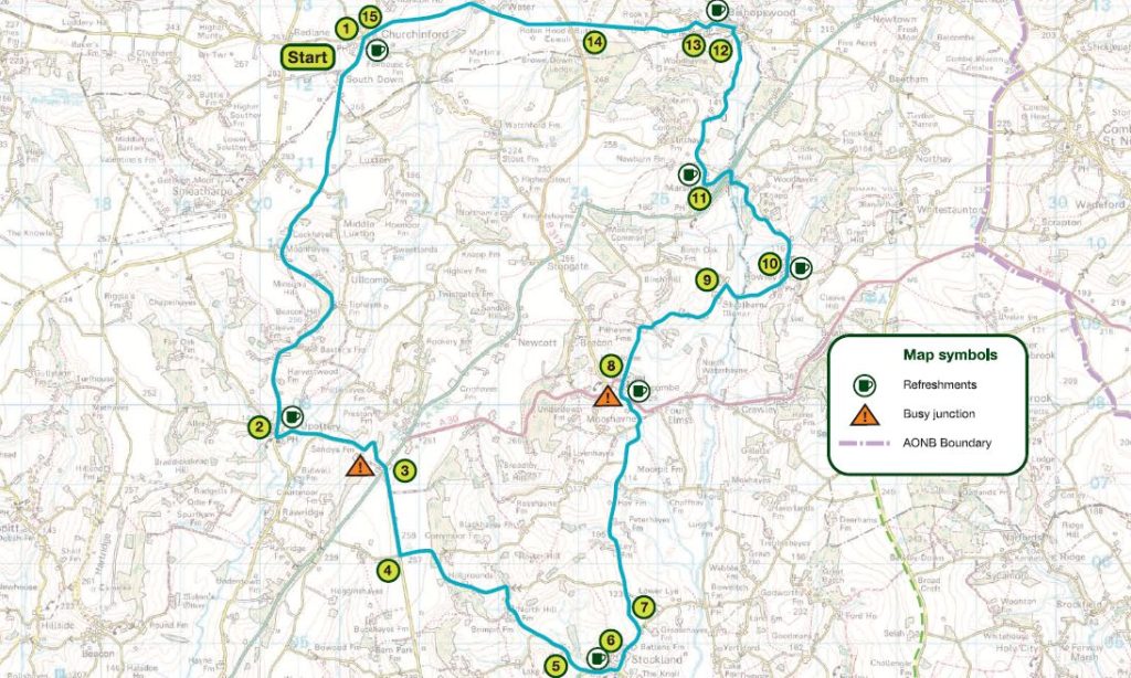
Churchinford, Yarcombe, Stockland, Upottery
Download PDFA moderate ride with one challenging uphill climb and several moderate uphill sections. Along the way, you’ll see a lakeside nature reserve, the seat of a former prime minister, and maybe a pot of gold! One of eight cycle routes in the Blackdown Hills National Landscape – Route 7.
Main route (1 – 15)
1 Turn left out of the car park and follow road for 4 miles to Upottery
2 Turn left, signposted Chard, just after the Sidmouth Arms
3 At crossroads use dedicated cyclist crossing to southwest of road junction, cross over the main road, signposted Stockland, Axminster
4 Turn left, signposted North Hill at Rising Sun Cross
5 At junction turn left into Stockland
6 Turn left at Stockland Village Cross
7 Turn left at Road Ends Cross, signposted Yarcombe and follow for 2 miles
8 At junction turn left on to the main road, and then first right, signposted Marsh, after Yarcombe Inn
9 At junction (Sheafhayne Cross) turn right, signposted Howley, Chard
10 Turn first left after Howley Tavern, and follow under the bridge into Marsh
11 Turn right after the Flintlock Inn (just before no entry signs) and follow for 1.5 miles
12 At fork in road, bear right down hill
13 At junction turn left into Bishopswood
14 At crossroads go straight over, signposted Churchinford, Hemyock
15 At junction in Churchinford turn right and right again into car park
Maps: This route is based on OS Explorer maps and is intended as a guide to cyclists. Refer to Explorer 128 or Landranger 192 and 193 when planning your visit.
General Information: For information about safe cycling and further information to help plan your visit, see www.blackdownhillsaonb.org.uk
Although every effort has been made to ensure the accuracy of the route directions and descriptions, responsibility cannot be accepted for any errors or omissions. If you discover any errors, please let us know.

Stockland, Yarcombe, Whitestaunton and Membury
Download PDFA moderate cycle ride with challenging climbs, and some interesting buildings to see along the way. The shorter route includes an exhilarating downhill section and a steep climb. One of eight cycle routes in the Blackdown Hills National Landscape – Route 8.
Main route (1 – 16)
1 Turn right out of car park and first right at Stockland Village Cross
2 Turn left at Road Ends Cross, signposted Yarcombe and follow for 2 miles
3 At junction turn left on to main road and then first right, signposted Marsh after Yarcombe Inn
4 At junction (Sheafhayne Cross) turn right, signposted Howley, Chard
5 Turn first left after Howlet Tavern
6 Turn right up hill just before stream and road bridge
7 Turn first right
8 At junction turn right
9 At junction turn right and follow for one mile
10 At junction turn right on to main road
11 Turn left, signposted Membury, Stockland, Animal Sanctuary
12 At junction turn right, signposted Membury, Stockland – follow for almost 3 miles
13 Turn right at Star Cross, signposted Membury and follow for nearly 2 miles
14 Turn right, signposted Kilmington, Axminster
15 At junction (Beckford Cross) turn right, signposted Stockland and follow for 2.5 miles
16 In Stockland turn right just after the school into the village hall car park
Shorter route – 12.5 miles (replaces stages 13 – 16)
a Turn first right, signposted Stockland and follow for 3 miles
b At junction (Stockland Village Cross) turn left, and first left into village hall car park
Maps: This route is based on OS Explorer maps and is intended as a guide to cyclists. Refer to Explorer 128 or Landranger 192 and 193 when planning your visit.
General Information: For information about safe cycling and further information to help plan your visit, see www.blackdownhillsaonb.org.uk
Although every effort has been made to ensure the accuracy of the route directions and descriptions, responsibility cannot be accepted for any errors or omissions. If you discover any errors, please let us know.