The Blackdown Hills National Landscape team has developed guidance to support capital ‘uplift’ funded applications for the 2025/26 period. This funding is intended for capital projects that contribute to achieving additional 30by30 habitat within the Blackdown Hills National Landscape area.
The guidance outlines how capital funding can be used to achieve 30by30 objectives and gives some examples of eligible projects. It also includes maps highlighting areas with ‘potential’ for enhancement to achieve ‘actual’ 30by30 habitat, focused within our existing nature recovery areas.
For further conversations regarding capital funded applications, please contact Hannah Metson Hannah.metson@devon.gov.uk
Overview
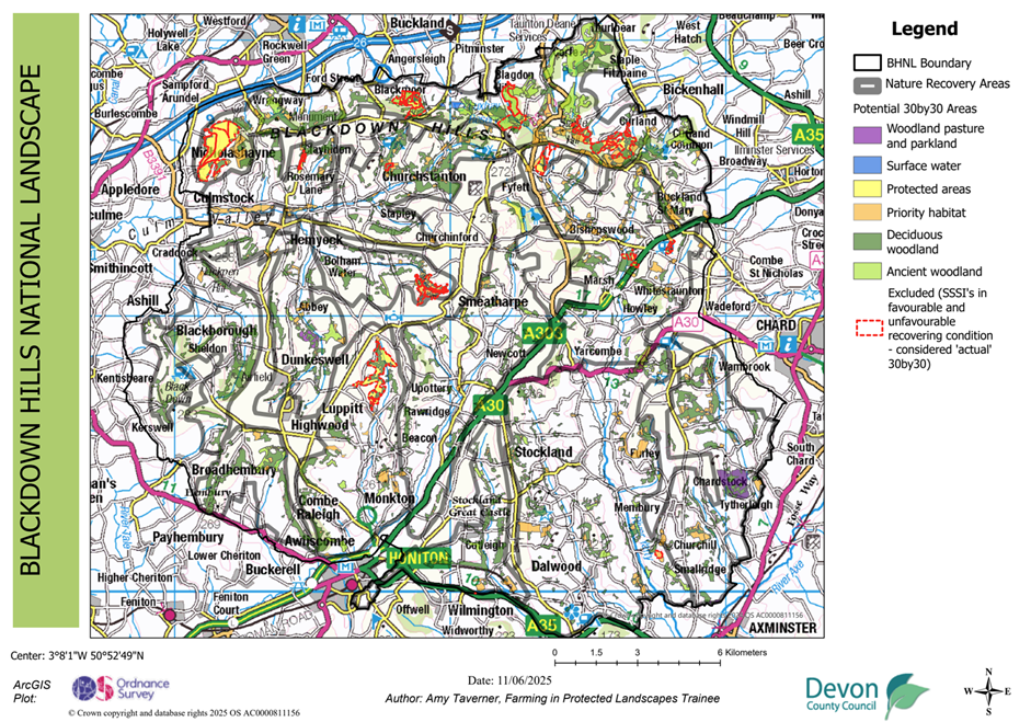
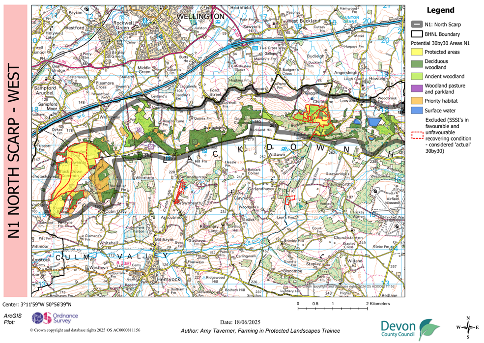
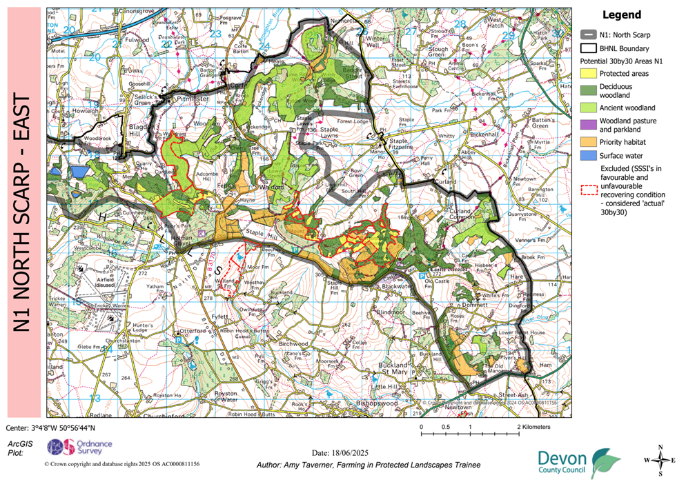
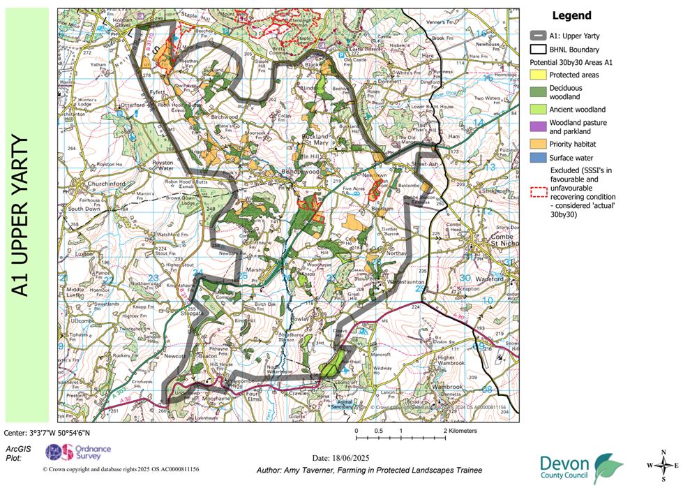
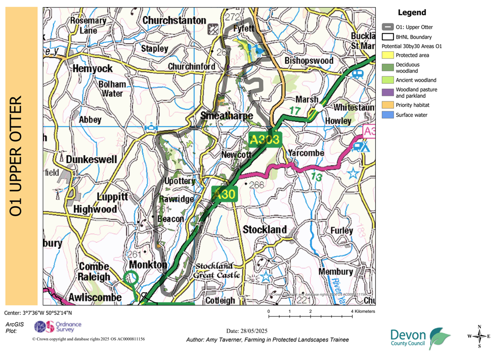
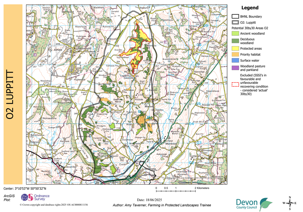
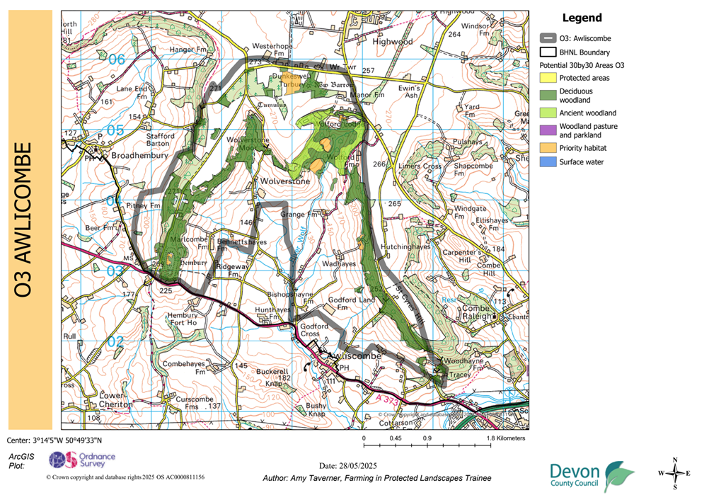
These maps are created using ‘potential’ 30by30 areas (National Landscapes Partnership, 2024). They illustrate areas, which if managed, can become ‘actual’ area to contribute towards the UK’s 30by30 goals. By concentrating on the Blackdown Hills National Landscape’s existing Nature Recovery Areas, capital uplift funding can be focused on ‘potential’ 30by30 within these areas.
Achieving 30by30 goals
There are two methods to create 30by30 habitat. Our priority is to convert the mapped ‘potential’ 30by30 habitat to ‘actual’ habitat, but there is still place to create/ restore habitat where it improves habitat connectivity.
- Convert ‘potential’ 30by30 habitat to ‘actual’ 30by30 habitat
- Creation/ restoration of connected habitat
In addition, maintaining condition and avoiding deterioration of priority habitat remains a key priority.
Note for context: the 30by30 classification 30by30 on land in England: confirmed criteria and next steps – GOV.UK links to the Protected Landscapes Targets & Outcome Framework (PLTOF) ) Protected Landscapes Targets and Outcomes Framework – GOV.UK, notably targets 1 to 4. This is because habitats created or restored can count towards PLTOF targets, as well as 30by30. The Government are still defining this synergy/ overlap and how to accurately record it.
1. Convert ‘potential’ 30by30 habitat to actual 30by30 habitat
The current ‘potential’ of the Blackdown Hills National Landscape to achieve 30by30 is 20% of the total area (i.e. restore all extant priority habitat). Of this, the current ‘actual’ (meeting 30by30) is 10% of the total Blackdown Hills National Landscape area (3,700ha), with the majority in Somerset.
Therefore, to reach 30by30, 10% more priority habitat would need to be re-created in the Blackdown Hills National Landscape
The mapped ‘potential’ 30by30 areas include regions which already have some protections or management in place, and habitats with important biodiversity value. The criteria used to identify these areas help determine which regions and habitats have the potential to contribute towards the 30by30 goal without significant land use changes, given support from landowners, land managers, targeted action, and investment. The term ‘potential 30by30 areas’ refers to broad areas and does not imply that these entire areas will be able to contribute to 30by30 in the future.
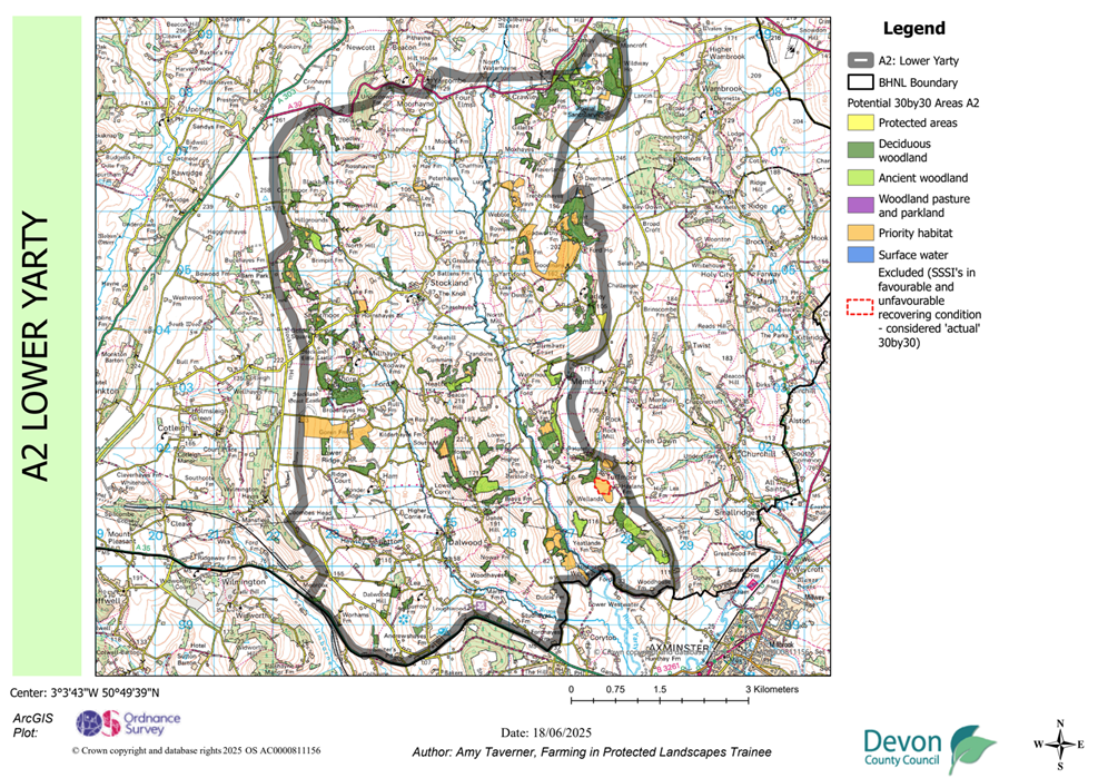
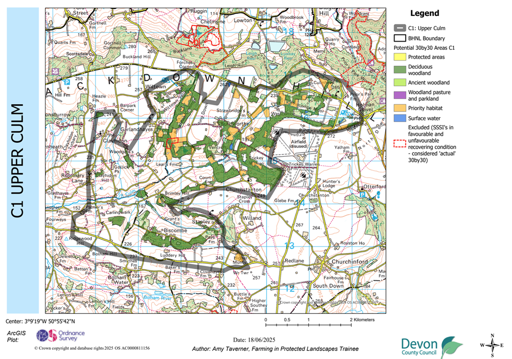
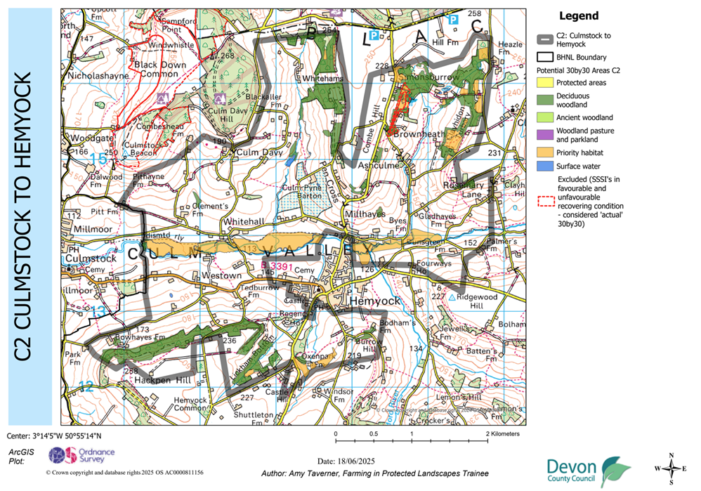
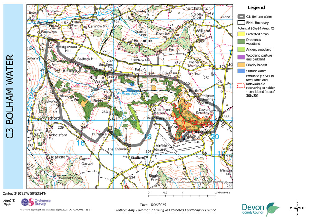
Red dashed outlines indicate Sites of Special Scientific Interest (SSSIs) that are predominantly in favourable or unfavourable recovering condition. These areas are considered by the government to already be classed as ‘actual’ area for 30by30. This means that they are not a priority for capital uplift 30by30 monies in the 25/26 financial year. Instead, capital uplift funding should be focused on potential 30by30 areas (see below). N.B. Other funding is still available for SSSIs including agri-environment schemes and Farming in Protected Landscapes (see Farming in Protected Landscapes – Blackdown Hills National Landscape).
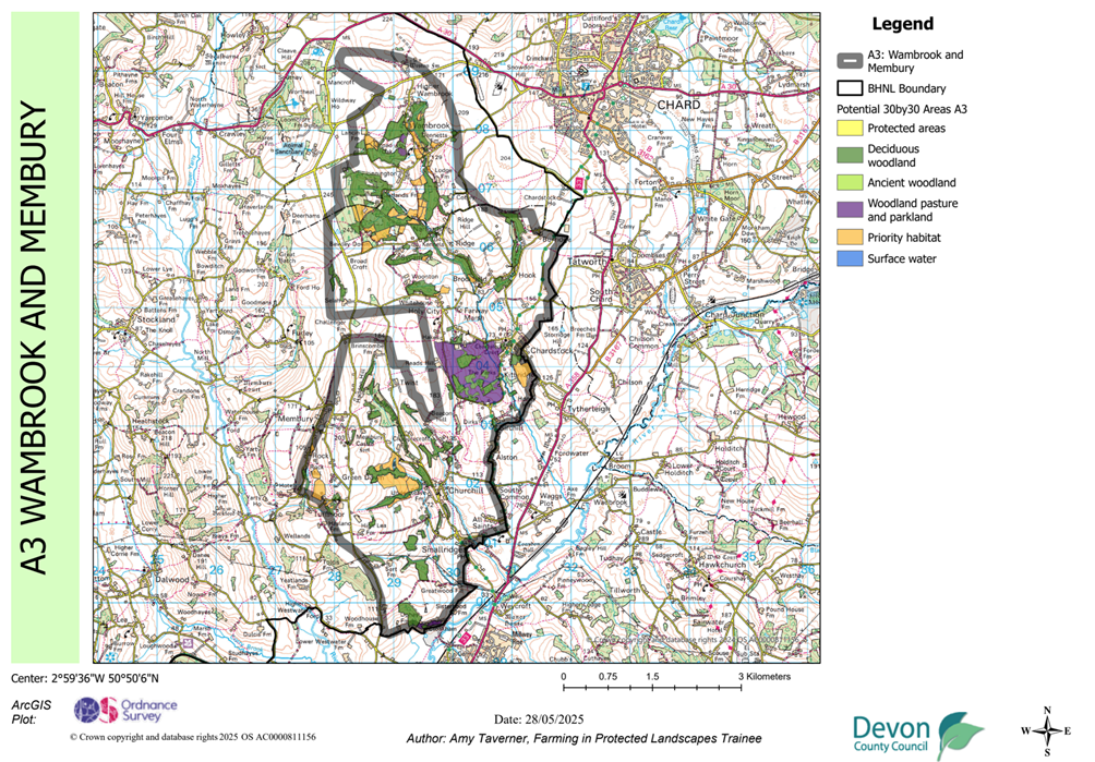
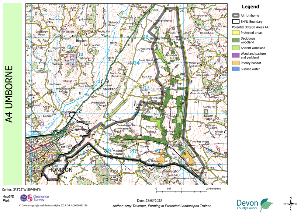
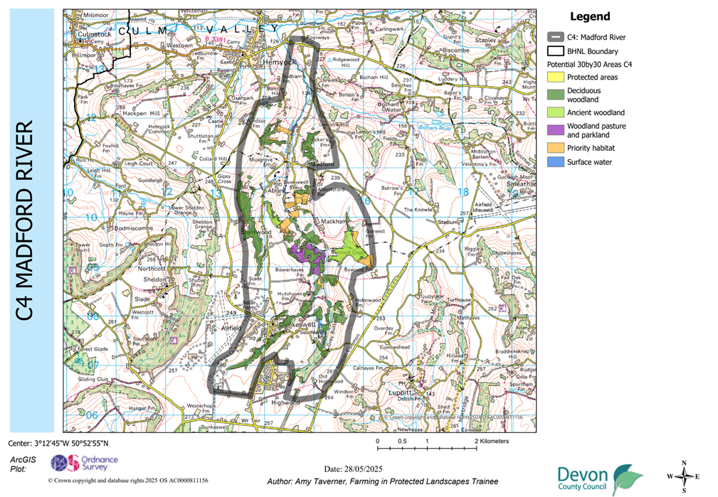
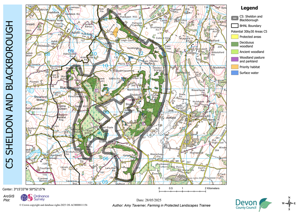
All other coloured areas (split by priority habitat type) indicate ‘potential’ 30by30 areas that are eligible for capital uplift funding in 25/26. Moving towards 30by30 will primarily be by management (DEFRA criteria 3) using capital monies. This states that ‘30by30 areas should be effectively managed and able to demonstrate overall progress towards in-situ conservation outcomes’. Management should provide confidence that the areas have the capacity to achieve and sustain such outcomes. Establishment of baselines to assess progress should be in place.
Areas mapped as ‘Potential 30by30 Areas’
| Protected areas | Special Sites of Scientific Interest (SSSIs), Special Protection Areas (SPA), Special Area of Conservation (SAC), Ramsar sites, Local Nature Reserves, National Nature Reserves. |
| Deciduous woodland | National Forest Inventory filtered to deciduous woodland categories. |
| Ancient woodland | Ancient Woodland data excluding conifers. |
| Woodland pasture and parkland | Wood pasture and Parkland data excluding conifers. |
| Priority habitat | Priority Habitat Inventory excluding deciduous woodland or peat. |
| Surface water | Surface water from OS OpenMap Local. |
2. Creation/ restoration of connected habitat
In addition to improving condition of habitat to take sites from ‘potential’ 30 by 30 area to ‘actual’ 30 by 30 area, priority habitat can be created/ restored to become ‘actual’ area for 30 by 30. This must be in areas where creation/ restoration improves connectivity between existing priority habitats classed as ‘potential’ 30 by 30 areas within the ‘potential’ 30 by 30 maps.
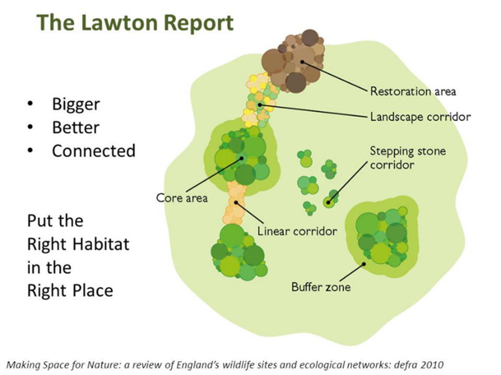
The schematic to the right, taken from the The Lawton Report (DEFRA, 2010) illustrates the importance of creating/ restoring connected ecological networks. This is valuable to allow species and genes to move between habitats.
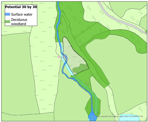
2.1. Example: Species rich wetland creation
The example to the left illustrates a grey hashed area intended for species rich wetland creation. Whilst the area is not entirely within mapped ‘potential’ 30 by 30 area, it is situated between surface water and deciduous woodland which is classed as ‘potential’ 30 by 30. Thus, wetland creation in this area would improve the connectivity between these habitats, subsequently qualifying for ‘actual’ 30 by 30.
The project could have additional value for contributing to ‘actual’ 30 by 30 by investing in management within the deciduous woodland.
Moving towards actual 30by30 within the Blackdown Hills
The Blackdown Hills National Landscape have been assigned £157,000 of capital uplift funding for 2025/26. This funding is for capital expenditure which can target ‘potential’ 30by30 areas and new connected habitats.
Capital uplift funding can be used in association with agri-environment schemes, so long as there is no double funding.
Examples of capital expenditure:
- Enable ‘sustainable’ grazing management- e.g. holding pens for cattle, livestock management (e.g. stock fencing), GPS (no fence) collars.
- Invasive scrub control using machinery- e.g. removal of invasive scrub on spring line mires and creation of butterfly flyways.
- Equipment to manage ‘difficult’ sites e.g. bracken basher.
- Bringing undermanaged woodlands back into management e.g. glade and ride restoration, machinery access, coppicing and thinning.
Connecting features (such as ‘new’ hedges and copses) and ‘stepping stones’ (areas restored through capital works to provide feeding opportunities for priority species).
Maps of Potential 30by30 within the Blackdown Hills National Landscape’s Nature Recovery Areas