
Chapter 6: Nature
Blackdown Hills National Landscape Management Plan 2025-2030
Chapter 6: Nature
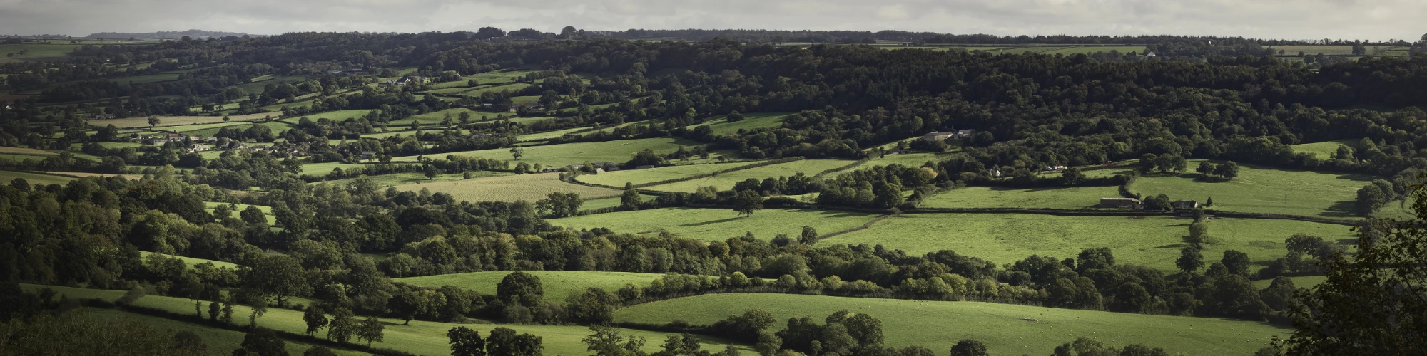
The biodiversity of the Blackdown Hills National Landscape is intrinsic to the area’s character and aesthetic appeal and is diverse, as a result of the area’s varied geology and landforms.
Its mosaic of priority habitat includes springline mire, heathland, woodland and species-rich grassland, all connected via hedges and banks, supports a wide variety of species. However, this very mosaic means that some habitats are fragmented, and condition of some are fragile. Measures to restore and connect habitats will benefit wildlife and deliver other ecosystem services.
In this chapter:
6.1 Objective – Nature
To ensure the effective conservation, enhancement, expansion and connectivity of habitats to form coherent and resilient ecological networks across the Blackdown Hills and beyond, facilitating the movement of species of conservation concern across the landscape.
6.2 Guiding principles – Nature
The guiding principles we adopt locally reflect the principles that National Landscapes across the country are adopting, while also recognising requirements specific to the Blackdown Hills.
- People need nature, wherever they are and whatever their ability or knowledge.
- Soil, air and water are the foundations of a healthy natural environment.
- When meeting our targets, we must not miss the point. (For example, it would be possible to deliver 30 by 30 with isolated sites that will not allow species to spread.)
- The natural landscape of the Blackdown Hills should be seen as a functioning whole.
- The Lawton Making Space for Nature principles of ‘better, bigger more and joined’ ensure that habitat networks are fit for purpose for nature to thrive in and adapt to climate change.
- What happens in the Blackdown Hills National Landscape is contributing to something much bigger. The Blackdown Hills is not an island – it links to the surrounding countryside.
- More wildlife habitat in the Blackdown Hills will deliver many wider benefits.
- Beyond Lawton, the mantra of ‘right tree, right place’ should be extended to ‘right habitat/species, right place’, allowing nature to flow. This should ensure that scarce and irreplaceable habitats are protected and that the development of one habitat does not damage the network of another.
- Some of the habitats and species in the Blackdown Hills are more threatened than others. We will therefore prioritise habitats and species of conservation concern, guided by the Blackdown Hills National Landscape Nature Recovery Plan.
- We will contribute to delivering the Devon Local Nature Recovery Strategy and Somerset Local Nature Recovery Strategy.
- We will embrace and promote the latest conservation practice where appropriate.
6.3 Targets – Nature
These are the Protected Landscape Targets and Outcomes Framework targets that we will contribute to:
Target 1
“Restore or create more than 250,000 hectares of a range of wildlife-rich habitats within Protected Landscapes, outside protected sites by 2042 (from a 2022 baseline)”.
Farmers will also be supported to create or restore 30,000 miles of hedgerows a year by 2037, eventually returning England’s hedgerows to 10% above their 1984 peak of 360,000 miles.
The apportioned target for Blackdown Hills National Landscape is to restore or create more than 2,919 hectares of a range of wildlife-rich habitats by 2042, equivalent to 145.96 hectares per year between 2022 and 2042.
During the lifetime of this Management Plan (2025-30) this equates to 730 hectares.
1.7% of the Blackdown Hills National Landscape is designated as a Site of Special Scientific Interest (SSSI). This means that there is significant potential to deliver against Target 1 outside of these nature conservation designated sites.
Target 2
“Bring 80% of Sites of Scientific Interest (SSSIs) within Protected Landscapes into favourable condition by 2042”.
Target 3
“60% of SSSIs within Protected Landscapes assessed as having ‘actions on track’ to achieve favourable condition by 31 January 2028”.
Target 4
“Continuing favourable management of all existing priority habitat already in favourable condition outside of SSSIs (from a 2022 baseline) and increasing to include all newly restored or created habitat through agri-environment schemes by 2042”.
30 by 30
The international obligation that the government has signed up to of 30% of land and sea managed for nature by 2030 is a current major policy driver. National Landscapes (15% of England) include 31% of England’s SSSIs, 22% of England’s broadleaved woodland and 18% of England’s deep peat. Blackdown Hills National Landscape should make a significant contribution to 30 by 30.
6.4 At a glance – Nature
Headlines from the State of the Blackdown Hills National Landscape report 2023
- There are 16 designated Sites of Special Scientific Interest (SSSI) in the Blackdown Hills National Landscape, occupying 640 ha (1.73%) of its area.
- 94% of the Blackdown Hills’ SSSIs are in a ‘favourable’ or ‘unfavourable recovering’ condition. This is an improvement from 2017. Then, only 90% of its SSSIs met the target. (However, this masks that only 19% are in ‘favourable’ condition).
- There are 4,724.43 ha of priority habitats covering 12.8% of the Blackdown Hills National Landscape (note that priority habitat data is incomplete in places and more work is needed on verification).
- There are 5,380 ha of woodland covering 14.5% of the Blackdown Hills National Landscape.
- There are 867 ha of ancient woodland covering 2.3% of the Blackdown Hills National Landscape.
- 45% of woodland is in active management.
- The overall ecological quality of most of the rivers in the National Landscape is moderate, none are in good or high status.
- Non-statutory designated sites for nature cover around 8.5% of the Blackdown Hills National Landscape.
- Otterhead Lakes Local Nature Reserve covers 0.1% of the Blackdown Hills National Landscape.
A focus on nature recovery
We know that delivering nature recovery in England with the current resources is failing.
In 2021, the Blackdown Hills National Landscape Partnership held three workshops with a mix of landowners, conservation organisations, neighbouring National Landscapes, community interest groups and other stakeholders. The aim was to engage partners and inspire and inform positive action to conserve existing wildlife and habitats across the Blackdown Hills and reinstate what’s been lost.
As a result of these workshops, a collective view was formed about what the priority measures for nature recovery (and delivery of other public goods and services) should be:
- Measures to slow the flow of flood water off the land, through nature-based solutions including tree planting, natural regeneration, leaky dams, additional water storage, hedgerow restoration, and improvement of soil infiltration.
- Measures to conserve soil, enhance soil quality, and prevent the loss of sediment and phosphates to watercourses, by reducing soil compaction, preventing soil erosion, and increasing soil organic carbon.
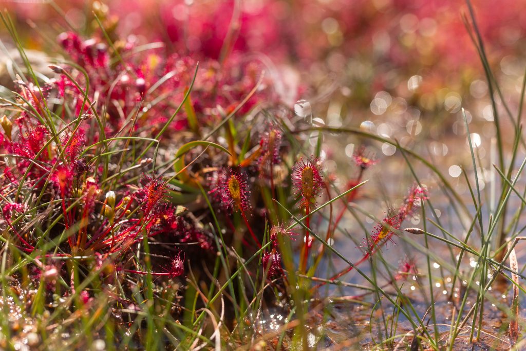
- Conservation of existing springline mire, wet and dry heath, species-rich grassland, and the prevention of loss of these habitats to scrub invasion, drainage, cultivation, inorganic fertiliser or herbicide application.
- Retention of long-standing permanent pasture, because of its high soil carbon content, undisturbed soil profiles, and botanical, fungal and invertebrate communities.
- Restoration or creation of new wildlife habitats such as ponds and wetlands, mires, species-rich grassland, hedgerows and broadleaved woodland.
- Measures to improve public understanding of farming and the environment in the Blackdown Hills, and community involvement in countryside management.
Following these workshops, a Nature Recovery Delivery Plan was produced (a map showing the Nature Recovery Areas can be found in the plan).
The 14 ‘Nature Recovery Areas’ (NRAs) identified in the delivery plan deliberately cover the entire National Landscape. This all-encompassing approach has been taken to create a holistic agenda for nature recovery, recognising the importance of measures which can be taken across the farmed and forested landscape.
All 14 Nature Recovery Areas include land where priority actions can and should be pursued to enable the recovery of habitats, species and ecosystem functions across the Blackdown Hills National Landscape. 13 are based on river catchment and sub-catchment boundaries, excluding most of the flat plateau lands. These Nature Recovery Areas generally represent ancient countryside on the valley sides and floodplains, with thick hedges and relatively small field sizes.
The 14th Nature Recovery Area covers the remaining high plateau land, together with some of the lower peripheral land around the boundaries of the Blackdown Hills National Landscape. These areas are largely agriculturally improved, with larger, late-enclosure field patterns. The nature recovery actions identified for these Nature Recovery Areas vary in their emphasis, from a focus on conserving and expanding existing habitat for biodiversity, to a consideration of opportunities for regenerative farming practices for soil conservation and hydrological management.
See also:
6.5 Priorities for action – Nature
This section sets out what we intend to prioritise and how these actions will contribute to each of our targets (see above).
As guided by the Lawton hierarchy, Target 4 is considered the top priority for Nature followed by Targets 2 and 3, then Target 1. This is because it is vital to make the existing priority habitat ‘better’ before considering creating new habitat, although potentially both could be done concurrently, so long as resources are focussed on restoration and not creation.
Priorities for Target 4
- Restore all priority habitat to a favourable condition.
- Enhance the data baseline, particularly for areas outside designated sites, including refresh / ground-truthing priority habitat maps to improve their accuracy and coverage. Note that the priority habitat inventory (PHI) is not considered definitive and underestimates the true extent of priority habitat. Other habitat inventories also underestimate the extent of habitat within mosaics.
- Conserve the characteristic ‘patchwork’ landscapes and habitat features for the Blackdown Hills National Landscape, particularly springline mires. Integrated natural capital benefits from nature recovery include carbon budgets, catchment-scale improvements to fluvial management, well-being benefits from access and recreation, and cultural and heritage enhancements.
Priorities for Targets 2 and 3
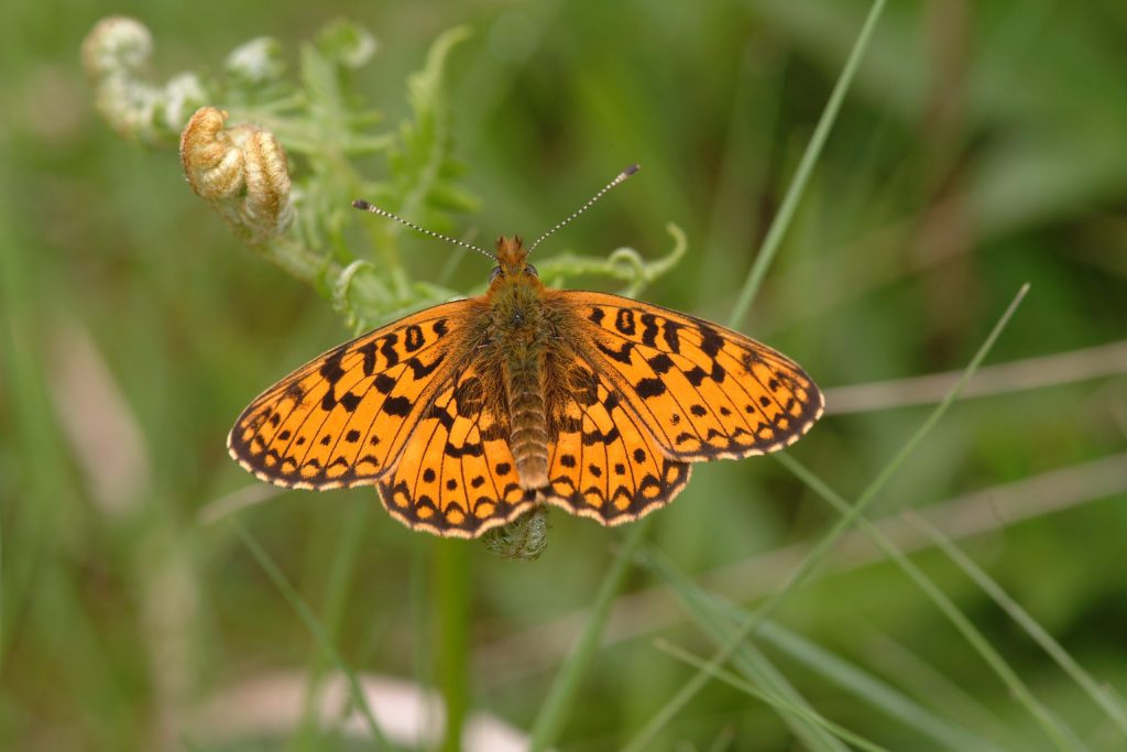
- Undertake significant work to move sites from ‘unfavourable recovering’ to ‘favourable’. This will require more condition surveying by Natural England and more incentives through Environmental Land Management (ELM) and other schemes, backed up by trusted local advisers. The current status of SSSI condition in the Blackdown Hills National Landscape is that only 16.3% is in favourable condition. 94% is in a favourable or unfavourable recovering condition. There is one Special Area of Conservation (SAC) in the Blackdown Hills National Landscape, currently failing to meet its conservation targets (marsh fritillary butterfly).
- Utilise this Management Plan to ensure appropriate and consistent delivery of the statutory duties arising from the Environment Act (2021) including Local Nature Recovery Strategies (LNRS),
- Ensure that activities for nature are consistent with actions arising from the Local Nature Recovery Strategies in Devon and Somerset.
Priorities for Target 1
- Focus on habitat creation in the highest priority areas, as per the Lawton hierarchy.
Actions to restore or create wildlife-rich habitat outside SSSIs and undertaken through established or future schemes, such as agri-environment schemes or government grants, will count towards Target 1.
This is because they are ‘reasonably expected to lead’ to the creation/restoration of wildlife-rich habitat that is of sufficient quality for the purpose of measuring progress towards Target 1.
Note that in the Protected Landscapes Targets and Outcomes Framework datasets, the new categories of ‘Grass moorland’, ‘Fragmented Heath’ and ‘Good quality semi-improved grassland’ are not actually considered to be priority habitats (by Defra and Natural England) and would therefore count towards Target 1 (not target 4).
The Blackdown Hills National Landscape will have an important role to play in the additional element of Target 1 that relates to hedges: “create and restore 30,000 miles of hedgerows each year by 2037”. The Blackdown Hills has a well-connected and dense lattice of hedgerows (one of its special qualities), with 4,440 km of hedges across the landscape.
30 by 30
The Blackdown Hills National Landscape is one of six national pilots developed by the Protected Landscapes Partnership, in conjunction with the National Landscapes Association. The outputs from this work are summarised as:
The current ‘potential’ of the Blackdown Hills National Landscape to achieve 30 by 30 is 20% of the total area (i.e. restore all extant priority habitat)
Of this, the current ‘actual’ (meeting 30 by 30) is 10% of the total Blackdown Hills National Landscape area (3,700ha), with the majority of this in Somerset.
Therefore, to reach 30 by 30, 10% more priority habitat would need to be re-created in the Blackdown Hills National Landscape i.e. c3,600ha. Although this figure is higher than the PLTOF target 1 figure, it should be the ambition via this Management Plan to achieve it.
Champion species
Following a process agreed nationally within the National Landscapes network, a suite of champion species of conservation concern has been identified and discussed with partners and national species champion organisations.
We are also working collaboratively with other National Landscapes to take local, regional and national actions for species that are linked to the Blackdown Hills National Landscape’s special qualities (such as springline mires) or that indicate the health of a well-connected landscape.
The champion species for the Blackdown Hills National Landscape are:
- Greater and lesser horseshoe bat; Bechstein’s bat.
- Hazel dormouse.
- White clawed crayfish.
- Brown hairstreak butterfly.
- Springline mire mosaic invertebrates including marsh fritillary, small pearl-bordered fritillary, double line moth, narrow bordered bee hawkmoth.
- Beaver.
Local Nature Recovery Strategies will be identifying priority species where conservation measures are required over and above broad habitat management and restoration. It is anticipated that the champion species listed above will align with the Local Nature Recovery Strategies, but this needs to be an iterative process and so a review maybe needed part way through the Management Plan cycle, to ensure alignment.
6.6 Policies – Nature
N1 Use the Lawton making space for nature principles of ‘better, bigger, more and joined’ to create networks that are fit for purpose for nature to thrive in and adapt to climate change.
N2 The mantra of ‘right tree, right place’ should be extended to ‘right habitat/species, right place’. This should ensure that scarce and irreplaceable habitats are protected and that the development of one habitat does not damage the network of another.
N3 Species of conservation concern will be conserved. Targeted action will be taken to support the recovery of champion/priority/indicator species.
N4 All public bodies within the Blackdown Hills National Landscape must have regard to Local Nature Recovery Strategy (LNRS). There should be alignment between the National Landscape and LNRS needs, and LNRS opportunities need to be reflected in partnership delivery on the ground.
N5 A strategic approach to the control, or eradication where feasible, of invasive non-native species will be taken where they threaten or damage local habitats and species and where action is practicable.
N6 Increased recreational pressure will be resisted at locations where unacceptable damage or disturbance to vulnerable habitats or species is likely to arise.
6.7 Context – Nature
6.7.1 Designated sites
Some areas of the highest conservation value are nationally important Sites of Special Scientific Interest (SSSIs), covering 639ha of the Blackdown Hills National Landscape.
In the Blackdown Hills, 2020 figures show that only 19% (122ha) are deemed to be in ‘favourable’ condition, with 75% ‘unfavourable recovering’ (477ha).There are some specific technical reasons for so few sites being favourable (often because parts of sites do not fully meet the ‘standard’ site/habitat expectations), but the large percentage of sites in a recovering condition is positive. This category has seen a significant increase since 2008 when 40% (254ha) were classed as unfavourable recovering, and over the same period the area considered unfavourable declining has moved from 118ha to none.
In addition to the 16 SSSIs in the Blackdown Hills National Landscape, there is one Special Area of Conservation (SAC) of European importance for nature conservation. This is located at Quants in the north of the Blackdown Hills, selected for its population of marsh fritillary butterflies, which occur on springline mire habitat mosaics. However, this species is now locally extinct at this site. Maintaining a viable population for this species requires a landscape-scale approach to connect fragmented populations further south in the Bolham Valley.
Just beyond the Blackdown Hills National Landscape boundary to the southeast is the River Axe SAC. The River Yarty, a major tributary of the Axe, rises and flows through the Blackdown Hills for most of its length. The Axe is designated as a watercourse with a chalk influence with the presence of water crowfoot species. The priority for the SAC is to reduce diffuse pollution (mainly phosphates and sediment largely from agriculture) to improve water quality.
The Somerset Levels and Moors Special Protection Area (SPA)/ Ramsar is located several kilometres to the north, fed in part by the tributaries of the Tone and Parrett that flow down from the north scarp of the Blackdown Hills.
6.7.2 The ecosystem approach
Soils provide a strong link between the physical environment and the wildlife, land use and cultural landscape. For example, the dark-topped, organic and peaty soils found on the plateau give an indication of the former extent of heathland vegetation, small remnants of which persist at Dunkeswell Turbary and North Hill. The freely draining land on the scarp with its dry, acid grasslands and woods, contrasts sharply with the perennially wet ground on the springlines. This supports wet woodlands, acid Rhôs pastures (purple moor grass and rush pasture community) and other wet grasslands, with mire and bog communities in more restricted sites such as Hense Moor.
It is essential that we understand and nurture our soils, to allow wildlife to thrive and farming to continue to take a sustainable harvest from our land. And the interaction of water with soil is critical to future climate resilience, so we must manage the journey of water through our landscape more effectively – from infiltration of rain into soils, slowing flow down slopes, holding water in mires and wetlands, maintaining moisture in times of drought, and allowing rivers to function naturally in their floodplains.
Wildlife habitats and species are part of a whole ecosystem, which includes our soils, water cycle, landform, rivers, and our human settlements. To pursue the health of any part of the nature of the Blackdown Hills, we need to understand how the whole ecosystem works, and where its functioning is being compromised. Outside of habitats like woodland, wetland and flower-rich grassland, good agricultural practices and a regenerative approach to soils, pasture and crops have huge implications for wildlife and healthy ecosystem function.
Smaller, more isolated patches of wildlife habitat are more vulnerable than larger, more connected networks. Populations of species like butterflies in isolated habitat patches cannot migrate to new patches. We will not retain our wildlife unless habitat becomes more extensive and connected. Connections could include more hedges, more rough vegetation around and between habitats, extended woodlands, and species-rich grassland or wetland to join up blocks of existing habitat.
Some of the habitats and species in the Blackdown Hills only occur in certain parts of the landscape – for example springline mire, around the springs between greensand and clay layers in the ground; and raft spiders, which only live on mires. Other habitats have a wider tolerance. To look after the diversity and specialness of Blackdown Hills’ wild places, we need to ensure our most characteristic and unique features are retained. Also, some of our wildlife, like the dormouse, is relatively common on the Blackdown Hills but rare nationally, so we have a particular responsibility to sustain what we have.
While some aspects of modern farming and forestry, and the economic pressures which drive them, have had a negative impact on wildlife in the last fifty years, the very character of our habitats is a consequence of farming, forestry and nature working in harmony. Without farming, we would not have flower-rich pastures, meadows or heaths. We need to enable the positive effects of sustainable farming to continue to produce a wildlife-rich landscape, while diminishing the negative effects.
Wildlife in the Blackdown Hills, just like human society, is at risk from the effects of climate breakdown – flood, drought, high winds and high temperatures. Some habitats and species are more vulnerable than others, because of their location, exposure, or relationship to landscape features which are particularly impacted by severe weather events. We need to consider these differences in trying to build greater resilience into the landscape to enable nature to tolerate and adapt to a changing, unstable, extreme climate.
Wherever they occur, wildlife habitats and species can and should benefit people. Nature is good for our mental and physical health and wellbeing, helps us work better together, provides enjoyment and tranquillity, provides settings and resources for business, and underpins everything that provides quality to our lives.
Wildlife habitats and the issues they face extend beyond the National Landscape boundary. The wildlife we protect and restore in the Blackdown Hills will contribute towards a national effort to restore a thriving, functioning natural environment across the UK. The UK has an international commitment to protect 30% of land for nature by 2030, and with organisations and land managers working together we can deliver a significant slice of that target.
6.7.3 Right habitat, right place
Existing wildlife habitats, like wetlands, mires, hedges, copses and ponds, help us in many ways; they slow the flow and hold water back during floods, they retain moisture during droughts, they provide shelter for livestock, and they catch sediment before it reaches rivers. New wildlife habitat, if sited thoughtfully, can help us address the wider environmental pressures we face.
Sometimes, creating a new habitat can destroy a rarer existing habitat, for example by planting woodland on flower-rich pasture on a slope. Furthermore, new habitat will be most valuable for wildlife if it is sited close to existing good quality habitat of a similar kind. And unless the soil type and hydrology are right for a given habitat, it won’t thrive. Where we can, we should let nature take the lead in determining what habitat develops where, rather than trying to be too directive. Often the ecologically richest places are in the ‘edge zone’ between habitats – we help nature to flourish where we allow it to relax and flow.
See also resources to help identify optimal locations where action might help build more ecologically resilient habitat networks that are ‘bigger, better, more and joined’, such as Natural England’s National Habitat Network Maps (available on www.magic.defra.gov.uk) and the Local Nature Recovery Strategies for Devon and Somerset.
Footer Navigation
Widget


Widget
