
Appendix 1
Blackdown Hills National Landscape Management Plan 2025-2030
Appendix 1: What is special about the Blackdown Hills?
‘Natural beauty’ is not just the look of the landscape, but includes landform and geology, plants and animals, landscape features and the rich history of human settlement over the centuries (Countryside Agency, 2001). These aspects of natural beauty are key physical components of the landscape. However, landscape is also about tranquillity, sensory experiences, cultural associations and the relationship between people and place. It is therefore important that the cultural, perceptual and aesthetic dimensions of landscape are also recognised as elements of natural beauty.
In Appendix 1:
Summary of the special qualities and distinctive characteristics
Natural capital stock and ecosystem services
Natural beauty factors
Natural England has developed a list of factors that contribute to natural beauty:
- Landscape quality – a measure of the physical state or condition of the landscape
- Scenic quality – the extent to which the landscape appeals to the senses (primarily, but not only, the visual senses)
- Relative wildness – the degree to which relatively wild character can be perceived in the landscape makes a particular contribution to the sense of place
- Relative tranquillity – the degree to which relative tranquillity can be perceived in the landscape
- Natural heritage features – the influence of natural heritage on the perception of the natural beauty of the area. (Natural heritage includes flora, fauna, geological and physiographical features)
- Cultural heritage – the influence of cultural heritage on the perception of the natural beauty of the area and the degree to which associations with particular people, artists, writers or events in history contribute to such perception
Special qualities
The designated Blackdown Hills Area of Outstanding Natural Beauty has a suite of special qualities that together make it unique and outstanding, underpinning its designation as a nationally important protected landscape. Special qualities may be considered as specific components of ‘natural beauty,’ distilling out the key attributes that combine in particular ways to form the natural beauty of the area. These are the special qualities, individually and in combination, that we need to conserve and enhance for the future and they should be considered in all decisions affecting the National Landscape.
Special landscape character
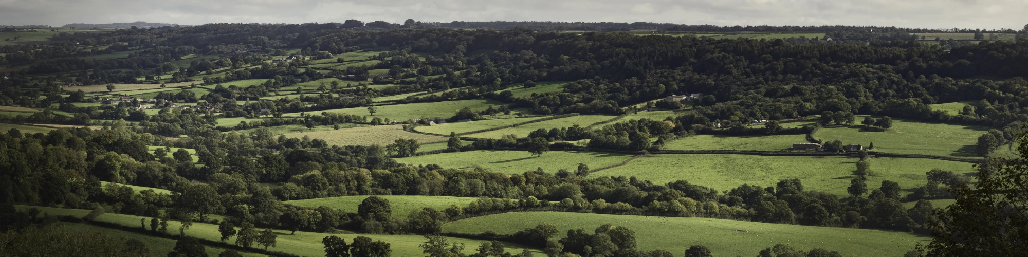
From the dramatic, steep, wooded north-facing scarp, the area dips gently southwards as a flat-topped plateau deeply dissected by valleys. This is the northern part of the East Devon Plateau – one of the finest, most extensive in Britain. The tops are open and windswept; in the valleys villages and hamlets nestle among ancient patterns of small, enclosed fields and a maze of winding lanes lined with high hedgebanks. The steep valleys support a patchwork of woodland and heath, nationally and regionally important habitats which support a wealth of charismatic and priority species and interesting plant communities.
Key to the Blackdown Hills designation as an Area of Outstanding Natural Beauty is the subtle combination of four outstanding aspects of the landscape (The Blackdown Hills landscape: A landscape assessment. Countryside Commission, 1989):
It is an area notable for its unspoilt rural character, which remains relatively undisturbed by modern development and so ancient landscape features, special habitats, historical and archaeological remains have survived intact. In the winding lanes, the hidden valleys, and traditional villages there is a sense of stepping back in time; of the links between nature and humanity. The countryside remains largely unchanged and there is an identifiable and characteristic vernacular, pastoral landscape.
There is a unique geology. The composition of the underlying Upper Greensand geology of the Blackdown Hills and the adjoining East Devon National Landscape is unique in Britain and is one of the area’s strongest unifying features. It has given rise to the distinct topography of flat-topped plateau, sharp ridges, and spring-lined valleys. The springs in turn have created the characteristic pattern of rough grassland, mire, and wet woodland vegetation on the valley sides. The nature of the Greensand rock has meant that these plant communities are particularly diverse. Moreover, the geology has provided a local building material, chert, which is uncommon elsewhere.
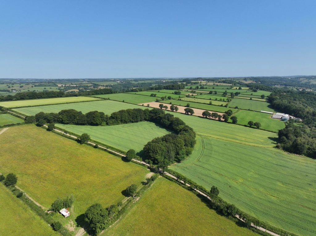
There is a diversity of landscape patterns and pictures. The visual quality of the landscape is high and is derived from the complex patterns and mosaics of landscapes. Although the scenery is immensely varied, particular features are repeated. There are long views over field-patterned landscapes. Ancient, species-rich hedgerows delineate the fields and define the character of the landscape, enclosing narrow twisting lanes. The open plateau is dissected by steep valleys, the slopes supporting a patchwork of ancient woodland. The history of medieval and parliamentary enclosures has resulted in a contrasting landscape of small fields in the valleys and larger fields with straight hedges on the plateau. There are patches of heath and common, bog and mire and there are fine avenues of beech along the ridge. At a more detailed level there is a variety of visual and ecological interest; heathland birdlife, ground flora of woodland and mire, and colourful wildflowers on hedge banks.
It is a landscape with architectural appeal. The landscape pattern is punctuated by a wealth of small villages, hamlets and isolated farmsteads of architectural value and distinctive character. Devon and Somerset are recognised nationally for their fine rural architecture, but the Blackdown Hills contain a special concentration of such buildings and where the vernacular character is particularly well preserved. Predominant materials are chert and cob with thatch, over time often replaced by corrugated iron, or clay-tiled roofs. The appeal lies in the way in which the buildings fit so naturally into their surroundings.
Special historic landscape
The Blackdown Hills landscape has great time depth, from prehistoric through to modern:
Prehistoric to Roman times
There are significant concentrations of early prehistoric evidence in the Blackdown Hills. Large numbers of Mesolithic flint and chert tools have been found, as well as Neolithic causewayed enclosures. Later prehistoric features include Bronze Age round barrow cemeteries and isolated barrows, and large Iron Age hillforts that take great advantage of the local topography. Of the 25 Scheduled Monuments in the area, 10 are Bronze Age barrows or barrow cemeteries and seven are hillforts.
Peat deposits in spring-line mires provide information back to prehistoric times, and the preserved pollen records show changes from woodland to pastoral and arable farming.
The Roman period is represented by military use of the Iron Age hillfort at Hembury, the later bathhouse at Whitestaunton and several ‘Romanised’ farms. Extensive evidence is emerging for Romano-British farms and field systems, that are particularly visible on LiDAR in marginal areas such as on and around the edges of commons/moors – some of these though may be Medieval.
Medieval period
Key medieval sites include Castle Neroche, an early Norman earthwork castle built on an earlier Iron Age defended site, and Hemyock Castle, a fortified manor house of the late medieval period. Dunkeswell Abbey, founded in the 13th century, had a significant influence on the landscape through its grange farms and probable involvement in iron production.
The Blackdown Hills’ distinctive field patterns and many dispersed farmsteads and hamlets originate from medieval times. Across the area are properties and settlements that were recorded in the Domesday Book. Historic landscape characterisation projects have identified a high proportion of the landscape as being of medieval origin. Enclosed, former medieval strip fields are well preserved throughout the area. Irregular fields and massive hedges in the valleys represent land taken directly into cultivation from woodland in the medieval period.
There is an extraordinary concentration of medieval buildings in the villages, as well as many deserted or shrunken medieval and post-medieval settlements, which reflect the ebb and flow of agriculture on marginal land. Ancient woodland, surviving from the medieval period, is still well represented, particularly on the northern escarpment. The Royal Forest of Neroche was finally enclosed in the 1830s but traces of the old wood-banks still survive.
Modern
Parliamentary Inclosure of heath and commons on the plateau tops in the 19th century has created distinctive landscapes of large regular fields with straight roads and beech hedges. The area contains some of the latest enclosures in Devon: Stockland Hill was not enclosed from heath until 1864, and Beacon Hill, Upottery, not until 1874.
The Wellington Monument, a prominent feature on the northern skyline, commemorates the battle of Waterloo. The National Landscape also contains important evidence from the second world war – the three airfields at Culmhead (Trickey Warren), Dunkeswell and Upottery (Smeatharpe). As well as the runways, a wide range of structures still survive at all three sites including pillboxes, aircraft dispersal pen and technical and domestic buildings. Some have been designated as Scheduled Monuments or Listed Buildings. There has been a substantial loss of hedgerows and orchards to meet the needs of modern agricultural since the second world war; simplifying parts of the landscape and masking their early origins.
The landscapes of the Blackdown Hills have been created by the interplay of people and the land over many centuries:
The unique geology of the area has had a strong influence on the industrial archaeology and landscape. Iron production is thought to have started locally in the later Iron Age, it was an important Roman industry and continued into the Middle Ages. Recent finds in Hemyock suggest an intensive iron industry existed in the late 9th and early 10th centuries. The iron ores were found at the junction of the Upper Greensand and the capping clay layer. There was extensive iron mining on the plateau, influencing the creation of plateau commons and improved/enclosed former heath, and now wooded upper slopes. The cratered landscape of opencast iron workings can still be seen in places on the plateau tops, such as Culm Davy, and iron slag finds are widespread.
There are claypits associated with medieval and post-medieval pottery production (a vast hoard of medieval pottery pieces found in Hemyock suggests it was an important local industry) and a number of largely 18th and 19th-century limekilns particularly around the Bishopswood and Wambrook area. Deliberate planting of former extraction pits with trees and orchards started in the medieval period and has contributed to the extensive pattern of small, dispersed woodland.
Mining of a hard seam of stone within the greensand for whetstone production reached its heyday in the 18th and 19th centuries. Indications of the mines can still be seen on the western escarpment around Blackborough and Broadhembury.
The Blackdown Hills has a distinctive local style of architecture. Local materials such as chert, cob, thatch, and clay tiles are used extensively, as well as limestone and Beer stone. The large number of surviving late medieval houses is exceptional. Many are Grade II* Listed Buildings and contain particularly fine woodwork screens, ceilings, and jetties; there are fine examples in Broadhembury.
Historic farmsteads are a key part of the National Landscape’s architectural, agricultural, and social heritage, and they too still survive intact and with unchanged associated farm buildings in exceptional numbers. Most farmsteads and hamlets are in sheltered valleys, often terraced into the hills. Villages are often at river crossings and crossroads in the valley floors, generally clustered around the parish church. Small stone houses often directly front or butt gable-end on to the narrow lanes. The lanes themselves host traditional roadside feature such as fingerposts and milestones. Topography often influences settlement pattern, such as Membury where the village straggles along the valley and Blackborough, where it follows the escarpment.
In terms of literature and the arts, over the centuries the Blackdown Hills landscape has inspired writers and artists who have left a legacy of cultural associations. Celia Fiennes, Daniel Defoe, and Rev John Swete all travelled through the area during the late 17th and the 18th century, providing informative descriptions and historical perceptions of the landscape.
In the early 20th century the Camden Town Group of artists, including Robert Bevan, Charles Ginner and Spencer Gore used the patterned rural landscape as inspiration for their impressionist paintings that provide records of the past. Today the texture, colours and light of the Blackdown Hills continue to influence contemporary artists and makers.
In terms of landscape features, although designed landscapes are not widespread within the area, there are some features that make a significant contribution. The Wellington Monument built between 1817 and 1854 is iconic, defining the north-west escarpment. Much of a Victorian designed landscape including walled garden, lakes and leats, still survives on the Otterhead Estate. Similarly, the large Victorian manors at Upottery and on the Tracey Estate, Awliscombe have gone, but their parkland, formal garden features and ancillary buildings can still be seen.
Special natural environment
The biodiversity of the Blackdown Hills is one of its greatest assets. The unique geology, rich history of human settlement and landscape patterns of the area have combined with traditional land management, climate and clean air to support a rich diversity of habitats and species.
The National Landscape is characterised by its intricate patchwork of semi-natural habitats, scattered throughout the landscape. This includes patches of woodland habitat, although there are larger concentrations of woodland in northern parts of the Blackdown Hills. In the past rough boggy parcels of land across the Blackdown Hills too agriculturally-poor for farming became used as a source of fuel and materials. Known as turbaries, local people had common rights to cut turf and dig peat for fuel, and they are now important habitats valuable for wildlife, often designated as SSSIs and nature reserves.
This immense variety, with patches of valuable habitat scattered throughout the landscape, is notable; these include flower-rich meadows, spring-line mire, wet woodland, heathland, calcareous grassland, ancient woodland, fen, and bog, connected by ancient hedgerows. At a micro-scale there is an abundance of lichens, mosses, and fungi. Bees, butterflies, birds, bats, and many other animals, some nationally scarce, thrive in the Blackdown Hills, feeding and breeding in the habitats the area provides. These habitats and wildlife bring colour, texture, sound and life to the landscape, epitomising the mental picture of the ‘English Countryside,’ which has, in reality, long since disappeared elsewhere.
Spring-line mires are a key feature of the Blackdown Hills National Landscape and comprise a matrix of plant communities and wetland features that support a range of specialist plants and animals, including insectivorous plants such as oblong-leaved sundew and pale butterwort. They are formed where the Greensand meets the clays, supporting priority habitats of wet grassland, heathland, mire (i.e. purple moor-grass and rush pastures) and woodland habitats. Linear features such as hedgerows are of value as wildlife in their own right and comprise important habitat for a range of notable and protected species including brown hairstreak butterfly and hazel dormouse. They have a role in landscape connectivity linking habitat patches, forming a network that allows species to move through the landscape, particularly in the provision of foraging habitat for mobile species such as bats. In places, rivers and streams host mammals including otters, beavers, and water vole, invertebrate including white clawed crayfish, and fish, including lampreys.
Summary of the special qualities and distinctive characteristics of the Blackdown Hills National Landscape
From the diverse characteristics, features and qualities outlined above, the following list summarises the special qualities that in combination create the particular sense and spirit of place that gives the Blackdown Hills its distinctive identity, in relation to Natural England’s list of natural beauty factors. All these special qualities require protection, conservation and enhancement if the area is to retain its character and status among England’s finest landscapes.
Landscape quality
- A managed landscape sculpted and maintained by the stewardship of generations of those who work the land
- Undeveloped skyline of the northern scarp slope is a prominent feature in views from the Vale of Taunton and beyond
- Rich mosaic of diverse and interconnected semi-natural habitats; a patchwork of woodland, heathland, meadow and mire linked by hedgerows
- Clear, unpolluted streams that meander down the valleys to feed the Yarty, Otter, Culm rivers
- Ancient and veteran trees in hedgerows, fields, and woodland
- A settled landscape with a strong sense of time-depth containing farmsteads and small scattered villages well related to the landscape
Scenic quality
- The elevation and long, panoramic views out from the Blackdown Hills create a sense of detachment from surrounding towns and transport corridors
- Unspoilt, panoramic views across flat-topped plateau and straight undisturbed ridge tops and over hidden valleys
- A well-wooded pastoral landscape with a strong pattern of hedgebanks and hedgerow trees
- Pattern of regular, larger-scale enclosure fields on the plateau contrasts with the smaller, curving medieval fields on the valley slopes
- Majestic avenues of beech trees along northern ridges
- Long straight roads across the plateau with verges and low, neat hedges give way to narrow, enclosed, high-hedged winding single-tracked lanes in the valleys
- Wellington Monument is a key landscape feature identifying the Blackdown Hills over a very wide area in all directions
Relative wildness
- A sense of remoteness enhanced by the exposure of the plateau and more intimate extensive woodland of the upper slopes and hidden valleys
- Wide open spaces provide exposure to the elements; big sky, windswept places, contrasts of sunlight and shadow
Relative tranquillity
- Areas of high tranquillity spared many of the intrusions of modern life, and places that offer a sense of detachment from surrounding towns and infrastructure
- Places to enjoy natural sounds; the melody of the song thrush and skylark, the call of buzzards
- Dark night-time star-filled skies contrasting with the light pollution of the surrounding towns
Natural heritage features
- One of the finest, most extensive plateaus in Britain; a distinctive landform that contrasts with the surrounding lowlands to the east, north and west
- The underlying Upper Greensand geology is unique in Britain
- The presence of straight, uninterrupted ridges are evident as a visual backdrop over a wide area
- Distinctive spring-line mires located at uniform height around the upper slopes of the valleys
- The varied landscape supports a rich assemblage of wildlife including many species of bats, butterflies and moths and meadow flowers and healthy populations of ferns, lichens, mosses, and fungi
- Ancient, species-rich hedges with many hedgerow trees and flower-rich banks; colourful displays of primrose and bluebells in spring
- A network of ancient semi-natural woodland linked by hedgerows support a thriving dormouse population
- Streams and rivers are home to otters, beavers, lamprey and the vulnerable white-clawed crayfish
Cultural heritage
- The number and extent of well-preserved 17th century and earlier buildings, and of complete traditional farmsteads in the local vernacular style – chert, cob, and thatch – are important elements of the landscape
- Ancient hillforts are prominent features on the ends of the plateau ridges
- Mining remains from the once internationally significant whetstone industry and extensive evidence of ironworking
- Three World War Two airfields and remains of their associated buildings are found on the high, flat land of the plateau
- A community with a strong sense of place closely linked to the land and its management, with a particularly strong tradition of hedge laying
- A landscape that has inspired artists from the early 20th century Camden Town Group to the Blackdown Hills Artists and Makers of today
Natural capital stock and ecosystem services in the Blackdown Hills National Landscape
Natural capital and the elements of natural beauty have a natural overlap: they are ways of categorising elements of the landscape and some of the benefits we derive from it.
Many of the elements which make up the natural beauty of the National Landscape can be described in terms of natural and cultural capital. Natural capital refers to both the living (e.g. fish stocks, forests) and non-living (e.g. minerals, energy resources) aspects of nature which produce value to people, both directly and indirectly. It is this capital that underpins all other capital in our economy and society, including cultural capital which is the historic environment and cultural landscape. Natural and cultural assets are the actual stock: living and non-living parts. From these assets we derive a flow of benefits known as ecosystem services. Essentially, natural capital is about nature’s assets, while ecosystem services relate to the goods and services derived from those assets.
The landscape of the Blackdown Hills provides a lot to those that live, work and visit here, from the quantifiable benefits of fresh food and clean water to those that are harder to define such as mental health benefits from contact with the natural environment.
These benefits can be defined as ecosystem services, all critical to maintaining human health and wellbeing. They are categorised into four types of services:
Provisioning services: the products we gain and use from the National Landscape, such as food, energy, and water
Regulating services: the natural functioning of the National Landscape purifies water, pollinates crops and maintains air quality
Cultural services: non-material benefits derived from interaction with the National Landscape, such as inspiration, education, and spiritual connection
Supporting services: the foundations for all other services – primary production (carbon fixation), the formation of soil, nutrient cycling, and water cycling.
A high-quality landscape (of rich natural and cultural heritage) delivers wide economic benefits. Some ecosystem services have related economic markets, some do not. Those that don’t can be considered ‘public goods.’
Public goods
Some ecosystem goods and services that flow from the landscape’s natural and cultural assets have a market which rewards the producer. Farming and forestry, although frequently not high return enterprises, are nonetheless producing goods for a functional marketplace.
However, some goods and services do not have a fully functional marketplace. For example, farmers who maintain species-rich grasslands are not rewarded by the market for the external value of that work. These are known as ‘public goods’ as they are non-excludable (i.e. no-one can be stopped from benefiting from that good) and nonrival (one person’s enjoyment does not preclude another’s). Private markets are developing for some of these goods, but while they do not exist public investment should be made to adequately reward the conservation of natural assets.
Public goods from the Blackdown Hills National Landscape could be considered to include:
- conservation of biodiversity
- conservation of built heritage
- maintenance of characteristic landscape features such as hedges and tree clumps (these will vary by landscape character area)
- providing clean air and water by taking uneconomic land management choices to reduce pollution (e.g. stopping fertiliser applications)
- maintaining rights of way
- providing educational access
Some of the ecosystem goods and services provided by the Blackdown Hills National Landscape include:
- Farmers and foresters produce food, fibre, timber, and wood fuel
- The Upper Greensand aquifer providing water for both public and private supplies
- The sources of the rivers Culm, Otter, and Yarty and some of the river Tone headwaters are in the Blackdown Hills and wetland mires help attenuate flows and trap sediment
- Carbon storage in woodland, lowland heathland, and peat deposits, for example in turbaries
- Hedgerows, rough grassland, wood pasture, and woodland help to regulate soil erosion and water flow, addressing flooding downstream, and support nutrient cycling
- Species-rich grasslands are biodiverse and support pollinating insects
- Historic features link, and add value, to the natural heritage stock and have cultural heritage value in their own right
- Recreational and access opportunities support the health and wellbeing of both residents and visitors
- The characteristic and richly patterned landscape and ancient features provide a strong sense of place and history
- The distinctive landform and coherent landscape are inspirational at a personal, cultural, and spiritual level
- The area gives access to clean air, tranquillity and freedom from noise and light pollution
Footer Navigation
Widget


Widget
