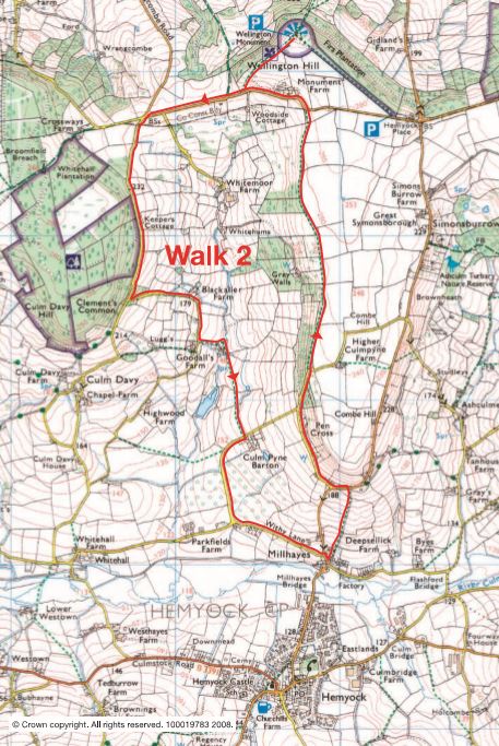
Medium difficulty. Distance 5.5 miles (9 km)
A strenuous 9 km (5.5 miles) walk well rewarded with lovely views of the Culm valley looking west and spectacular views of the Quantocks and beyond from the Wellington Monument.
From Lower Millhayes, go up some steps and past a children’s play area into Higher Millhayes; go left, then take the footpath on the right going between a house and a bungalow. Walk straight uphill across two fields keeping close to the right-hand bank. Cross over a stile into a third field (the very wet ground here is due to a springline) then straight ahead to another stile and onto a main road. Turn left and, after 100 m, take the first lane on the right.
Continue along the lane for 1 km until it turns sharp right. Take the footpath on the left and continue straight ahead for a further 1.5 km. This is a lovely, level stretch going through fields and woods with views across to Blackdown Common and, towards the end, a glimpse of the Wellington Monument towering over the trees. The footpath ends at a stile on to a main road. This is the ridgeway: an ancient route along the northern edge of the Blackdown Hills. It is now a fast road, so look out for traffic! Walk on the outside of each bend so cars can see you (this means crossing the road several times- take care!)
Turn left and go 0.5 km to a stile with a footpath sign on the right (this is in a thick hedge and quite easy to miss, but it comes just after a gated track on the left. If you reach a bridleway on the right, you have gone too far). Take the footpath across a field to a line of trees, then follow the trees uphill to the Monument. You are now standing on the northern scarp of the Blackdown Hills looking out over Taunton Vale to the Quantocks and Exmoor beyond.
To continue the walk, retrace your steps back to the main road, (blind bend- beware!) turn right and walk 0.5 km to a crossroads where the main road turns sharp right. Take the lane on the left signposted Culmstock.
After 1 km take the first lane on the left which goes downhill for 0.5 km. Just before Goodhall’s Farm on the right, take the footpath on the left, which goes down a grassy track to some old stone barns, over a small stream and into a field on the right. Follow the obvious path across two fields and an orchard and onto a lane. Turn right and walk to a T-junction, turn left (signposted Hemyock) to another T-junction. Turn right (this is a busy road, so beware of traffic) and then second left into Lower Millhayes.