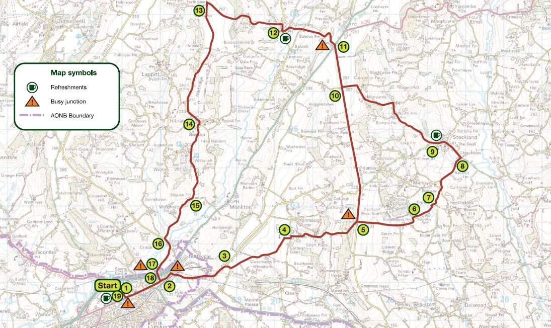
Hard difficulty. Distance 20 miles (32 km) or an optional shorter route of 17 miles (27 km)
A challenging 20-mile ride or an optional shorter route of 17 miles. Explore the Blackdown Hills countryside, with its iron-age hill forts. There is a railway station at Honiton, so this is a good ride if you’re planning to access the Blackdown Hills by train. One of eight cycle routes in the Blackdown Hills National Landscape – Route 6.
Main route (1 – 19)
1 Turn left out of the car park and left at traffic lights and follow to the end of the High Street
2 At roundabout turn left, signposted Exeter and London, and then right after 50 metres, signposted Cotleigh, Stockland
3 At top of hill turn right and then left after 50 metres, signposted Cotleigh
4 At junction turn left, signposted Cotleigh, then first right
5 At Stockland Hill, go straight over, signposted Heathstock, Broadhayes
6 Turn right at Shorehead Cross, signposted Heathstock, Ford, Stockland
7 At junction (Ford Cross) turn left, signposted Heathstock, Stockland
8 At junction (Cookers Elm Cross) turn left into Stockland
9 Go through village and turn right just next to Lark Rise House
10 At crossroads at top of hill turn right
11 At crossroads use dedicated cyclist crossing to southwest of road junction. Cross main road, signposted Upottery
12 At junction in Upottery turn right, signposted Churchinford, then first left after 75 metres, signposted Hemyock
13 At junction (Mathayes Cross) turn left, signposted Beacon
14 Turn right, then left at Beacons Cross, signposted Wick
15 At junction bear right
16 At junction turn left on to main road
17 At junction turn right, signposted Honiton
18 At roundabout turn right on to Honiton High Street
19 At second set of traffic lights turn right, signposted Cullompton A373 and then right into car park
Shorter route – 17 miles (replaces stages 5 – 10)
At crossroads (Broadhayes Cross) turn left on to main road and then go to instruction 11
Maps: This route is based on OS Explorer maps and is intended as a guide to cyclists. Refer to Explorer 128 or Landranger 192 and 193 when planning your visit.
General Information: For information about safe cycling and further information to help plan your visit, see www.blackdownhillsaonb.org.uk
Although every effort has been made to ensure the accuracy of the route directions and descriptions, responsibility cannot be accepted for any errors or omissions. If you discover any errors, please let us know.