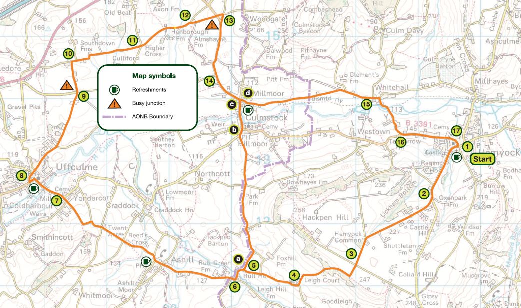
Medium difficulty. Distance 11 miles (18 km), with an optional shorter route of 7 miles (11 km)
A leisurely ride, with a climb near the start. On your way you’ll see Coldharbour Mill, a yew tree growing out of a church tower, and the beacon house on Culmstock Common. One of eight cycle routes in the Blackdown Hills National Landscape – Route 1
Main route (1 – 17)
1 Turn left out of car park and left just after the Catherine Wheel
2 Turn right at Lickham Cross
3 At crossroads (Leigh Cross) go straight, signposted Leigh
4 At junction turn right
5 At junction turn left
6 At junction turn right, signposted Ashill, Uffculme
7 At junction (cemetery corner) turn left onto main road, signposted Uffculme
8 Turn right at Uffculme just before the Ostler Inn
9 At Penslade Cross go straight over, signposted Penslade
10 At junction turn right
11 At crossroads (Higher Cross) go straight over, signpost Nicholashayne
12 Turn first right
13 At crossroads turn right on to main road, signposted Culmstock
14 Turn left at village hall in Culmstock and then first right by red phone box
15 Turn right at Whitehall Cross, signposted Hemyock
16 At junction turn left, signposted Hemyock
17 Turn right and return to car park
Shorter route – 7 miles (replaces stages 5 – 14)
a At junction turn right, signposted Culmstock
b At junction turn right
c Turn first right after Culm Valley Inn and go through residential area to reach main road
d Turn right onto road
Go to instruction 15
Maps: This route is based on OS Explorer maps and is intended as a guide to cyclists. Refer to Explorer 128 or Landranger 192 and 193 when planning your visit.
General Information: For information about safe cycling and further information to help plan your visit, see www.blackdownhillsaonb.org.uk
Although every effort has been made to ensure the accuracy of the route directions and descriptions, responsibility cannot be accepted for any errors or omissions. If you discover any errors, please let us know.