Medium difficulty. Distance 6.5 miles (10.5 kilometres)
The walk to Chardstock is delightful and contains a wide variety of scenery. The return, on quiet lanes, provides good views in all directions.
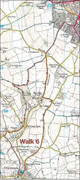
The route is described from the starting point of St Mary’s Church, Chard.
From the church head gently uphill along Church Street. Turn right into Summerfields Road and then left into Mintons Orchard. Turn into Alun Rees Way and after about 10 metres take a footpath on your right, between houses. At the end, climb a stile. Ahead and slightly to your right, follow a clear wide footpath up the left-hand edge of a field. At the top, you will join Bounds Lane.
Turn left and very soon you will see a gateway, from which two footpaths begin. Take the left-hand option, diagonally across the field and then beside the hedge. At the end of the field turn left and then almost immediately right. At the bottom of a dip, climb a stile in the hedge on your left and follow this field edge down to join a wide track. Turn right. After about 300 yards and precisely on the county boundary, a track doubles back on your left. Follow this for half a mile to a lane.
Keep ahead, following a sign for Farway at Hook Cross. With the sound of running water never far away, the lane bends right and then left. Just before a road junction take the footpath on the left. It descends to a bridge over a little stream and then climbs, slightly left, to a gate. The views behind you and to your right are excellent. Now it’s straight on through gates and across fields towards the church at Chardstock.
In the village, turn left and then left again at the George Inn. At Harestone Cross stay ahead and later ignore a lane on your right. You are up on one of the plateaus of the Blackdown Hills, and there are fine views to enjoy. At the next road junction turn left (for Cotley) and soon after bear right at a fork. This lane returns you to a familiar spot from earlier in the walk. Turn right to retrace your steps back to Chard, which will soon spread out in front of you.