
Landscape Character Assessment summary
Blackdown Hills National Landscape Management Plan 2025-2030: Supporting information – landscape character assessment topic paper
This is an updated version of a document originally included as an annexe to the previous management plan 2019-24. It summarises landscape character assessment information relating to the Blackdown Hills and supplements the Management Plan.
In this topic paper:
Landscape character assessment (LCA)
What information does the Devon LCA contain?
Other relevant landscape assessments
Landscape character types of the Blackdown Hills
Devon character areas of the Blackdown Hills
Landscape Character Assessment
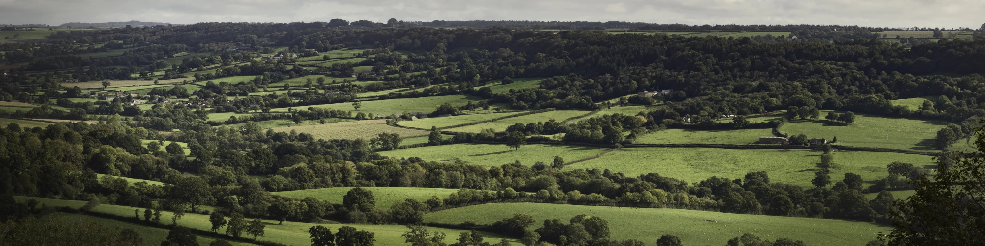
Landscape character describes the qualities and features that make a place distinctive. It can represent an area larger than the Blackdown Hills or focus on a very specific location. The Blackdown Hills National Landscape displays a variety of landscape character within a relatively small, distinct area. These local variations in character within the National Landscape’s landscape are articulated through the Devon-wide Landscape Character Assessment (LCA), which describes the variations in character between different areas and types of landscape in Devon and includes the entire National Landscape.
What information does the Devon LCA contain?
Devon has been divided into unique geographical areas sharing similar character and recognisable at different scales:
7 National Character Areas, broadly similar areas of landscape defined at a national scale by Natural England and named to an area recognisable on a national scale, for example, ‘Blackdowns’ and ‘Dartmoor’. There are 159 National Character Areas (NCA) in England; except for a small area in the far west which falls into the Devon Redlands NCA and a very small part in the north which is within neighbouring NCAs, the Blackdown Hills National Landscape is within Blackdowns NCA. Further details can be found here: https://nationalcharacterareas.co.uk/
68 Devon Character Areas, unique, geographically-specific areas of landscape. Each Devon Character Area has an individual identity, but most comprise several different Landscape Character Types. Devon Character Areas are called by a specific place name, for example, ‘Blackdown Hills Scarp’ and ‘Axe Valley’.
37 Landscape Character Types (LCTs), generic landscapes that share similar characteristics but may occur in different parts of Devon. Landscape Character Types allow different landscapes to be compared. Landscape Character Types have a reference number and are called by a descriptive name, for example, ‘1E Wooded ridges and hilltops’.
LCTs provide the basis for the East Devon and Blackdown Hills Landscape Character Assessment (2019).
Other relevant landscape assessments:
Mid Devon LCA (2024), complementary to the East Devon and Blackdown Hills LCA and part of the Devon-suite:
Somerset (2024):
https://somerset.digital/landscape-character-assessment/
The Blackdown Hills landscape, 1989
Undertaken by Cobham Associates for the Countryside Commission to inform the Area of Outstanding Natural Beauty designation. It identified six ‘visual character zones’ and described the outstanding qualities of the area. Only a few reference copies now remain, but it has been the foundation for much subsequent landscape-related work.
Historic Landscape Characterisation is a method for understanding and mapping the landscape that we see today with reference to its historical development. For the Blackdown Hills, the Devon study was undertaken between 2001 and 2004 (published 2006) and the Somerset and Exmoor National Park Historic Landscape Characterisation Project was undertaken in 1999-2000.
Landscape character types of the Blackdown Hills
For full profiles see https://eastdevon.gov.uk/planning/planning-policy/environment-and-green-infrastructure/landscape/
Note that some of the key characteristics relate to geographies broader than the Blackdown Hills National Landscape.
| Landscape Character Type | Location | Key characteristics |
| LCT 1A: Open inland planned plateaux | Extensive areas of high ground throughout the National Landscape which fan out into narrower ridges. Generally lie with a north/south trend except in the north where they lie east/west. | High, open flat plateaux comprising a series of long, narrow ridge tops, sometimes undulating. Little surface water. Occasional copses and conifer plantations punctuate the open farmland. Boundary trees along roads and hedgerows mostly beech in north, and oak/ hazel further south and around plateaux edges. Predominantly pastoral farming on heavy soils, with some arable. Regular, medium-large scale fields bounded by well-trimmed hedges on narrow earth banks. Semi-natural habitats include patches of heath, unimproved grassland and wide verges. Archaeology and cultural heritage includes prehistoric barrow cemeteries, Iron Age hillforts, later beacon and military sites. Settlement generally comprises isolated farmsteads and clusters of buildings at crossroads. 20th century settlement associated with airfields. Long, straight roads in the centre of ridges, often lined with beech avenues, with narrower, winding roads towards the edges. Few public rights of way. A very uniform appearance, with a simple landscape pattern and often a fairly large scale. Extensive views often blocked by woodland on boundary or roadside trees, but occasional long views. Wellington Monument, Gittisham masts and Stockland transmitter are landmarks. |
| LCT 1E: Wooded ridges and hilltops | Outliers at the end of ‘fingers’ of plateaux LCT. The only area of this type in the Blackdown Hills is the ridge running north/south from Stockland to Dalwood. | Small hills and associated small ridges, often isolated outliers of the plateaux. Species-rich hedgebanks and tree rows, ancient woodland and great species diversity with oak and ash common as hedgerow trees and flowering cherry in woodland. Also areas of conifer plantation. Small to medium irregular fields and spring line mires. Mixed woodland and some pasture, with occasional arable use. Semi-natural habitats include woodland, hedgebanks, verges, springline mires and streamside vegetation. An historic landscape with surviving medieval lanes, farmsteads and enclosure patterns. Prominent hills were used as beacon sites. Sparsely settled, with scattered farms nestled at the base of hills, or occasionally on ridge-tops. Narrow, enclosed winding lanes lined with species-rich banks climb ridges, often becoming less enclosed on ridge tops. There are occasional green lanes and public rights of way. Feels high and frequently remote, with little traffic, and a sense of detachment from surrounding lower land. Limited views out from lanes, but occasional spectacular views out from ridge tops. Forms the backdrop and skyline in views from valleys below. |
| LCT 2A: Steep wooded scarp slopes | Closely related to the plateaux (LCT 1A) sitting around the edges of the western and central plateau. Absent from the south-east part of the National Landscape. It is distinguished from the less steeply sloping land below by being generally wooded and lacking settlement. | A narrow band of steeply sloping land immediately below the plateau edges. Underlying greensand geology contains springlines. Extensive woodland, both deciduous and coniferous. Trees and hedgerows increase its wooded appearance. Notable mature oak and ash trees, with beech in the north. Land use of mixed woodland and semi-improved or unimproved pasture. Small scale, irregular field pattern. Many patches of semi-natural habitats, including springline mires, scrub, grassland and woodland. Concentration of Iron Age hillforts in prominent locations. Also Roman and medieval ironworking sites, and medieval farmsteads, banks, fields and lanes. Lightly settled, with occasional scattered farms, often nestled in folds of the scarp. Narrow winding lanes with well-treed banks. Lanes often run at an angle to the slope. Some green lanes and footpaths, but much of the LCT is inaccessible. Strong sense of enclosure in wooded areas, and a contrast of light and darkness. Irregular fields create varied and distinctive patterns. Seasonal contrasts in colour, particularly in deciduous woodlands, including spring bluebell woods and autumn leaves. From less wooded areas, and openings in trees, there are sudden and spectacular views over surrounding landscapes. Strong sense of tranquillity over much of the LCT, particularly away from roads and settlements. |
| LCT 3A: Upper farmed and wooded slopes | Frequently occurring extensive areas along the upper slopes of rivers valley throughout the area. | Undulating upper valley slopes on Greensand, below the scarp slopes or plateaux. Small V-shaped valleys on upper slopes. Deciduous woodland and copses, especially on upper slopes. Hedgerow trees (mostly oak and ash) and some parkland trees add to the green and lush appearance. Well-treed pastoral farmland, with some arable cultivation on lower slopes. Small to medium-size fields with irregular boundaries. Associated with traditional Devon smallholdings. Rich concentration of archaeological sites from all periods, but with many surviving medieval features including field patterns, churches, farms, villages and lanes. Wide, species-rich hedges with many hedgerow trees. Grassland, stream and woodland habitats add to rich biodiversity. A dispersed settlement pattern of isolated farms and small villages. Villages are often nucleated around a church, and contain local stone (chert) and cob buildings. Some are estate villages. Very winding narrow lanes, many sunken with high banks and flower-rich verges. An intimate and intricate landscape with wider views often confined by vegetation. Where views occur, they contain distinctive patchwork patterns of fields. Relatively remote and tranquil with little obvious modern development. Association with the early 20th century Camden Town school of artists in Blackdown Hills. |
| LCT 3B: Lower rolling farmed and settled slopes | Occupies a sloping transitional zone above the flat river valleys and tributaries but below the steeper, generally more wooded slopes. In the Blackdown Hills this LCT is mainly confined to the northern fringes and the south-east of the area. | Gently rolling landform, sloping up from valley floor. Numerous shallow valleys contain small streams. Red sandstone geology apparent in cuttings and soils in west of study area. Many hedgerow trees, copses and streamside tree rows. Oak and ash predominate, and there are small blocks of woodland. Predominantly pastoral farmland, often with a wooded appearance. Variable sized fields with wide, low hedged boundaries and a mostly irregular pattern, reflecting different phases of enclosure. Semi-natural habitats include streams and ditches, grassland, woodland and trees. Numerous historic landscape features including farmsteads, lanes, villages and churches. Concentrations of Roman sites. Settled, with various settlement sizes, building ages, patterns and styles. Various building materials, including stone, cob, whitewash/ render, slate, thatch and tile. Winding, often narrow sunken lanes, with tall earth banks. Local examples of deep cuttings through sandstone, particularly at entrances to settlements. A relatively enclosed and sheltered landscape. Some parts of the LCT feel well settled, whilst others feel exceptionally remote, with very little traffic. Views tend to occur across valleys, rather from within them. Higher land in other LCTs forms the backdrop to views. Often strong colours within the landscape, influenced by underlying geology, season and choice of crops. |
| LCT 3C: Sparsely settled farmed valley floors | The upper parts of the valleys of the Culm and Otter rivers, and most of the Yarty valley. | Open, flat landform, often with distinct vegetated floodplain edge. Winding river courses with main channels and smaller tributaries. Active river processes. Willows and other riverside trees along river banks and floodplain edges. Occasional patches of wet woodland. Pastoral land use with wet meadows and some arable, with variable field sizes. Hedges, not banks, on the boundaries with rising land. Watercourses are valuable semi-natural habitats, providing a range of aquatic and riparian habitats. Water meadows may also be species-rich. Historic bridges (including examples of medieval packhorse bridges) and mills. Very sparsely settled, with farms sited adjacent to the LCT above the flood plain. Network of narrow winding lanes in some valleys, but generally access is limited to bridging points and occasional riverside paths. Main roads cross some valleys. In-use and former railway lines (one now a tramway) utilising flat valley floors. Open internally, with views out screened by boundary vegetation. Long views along valleys, especially from bridges, framed by valley sides. Strong sense of tranquillity, particularly away from roads. Strong seasonal changes, particularly during times of flood. Simple landscape pattern, particularly distinctive seen in views from higher land. |
Character Areas of the Blackdown Hills
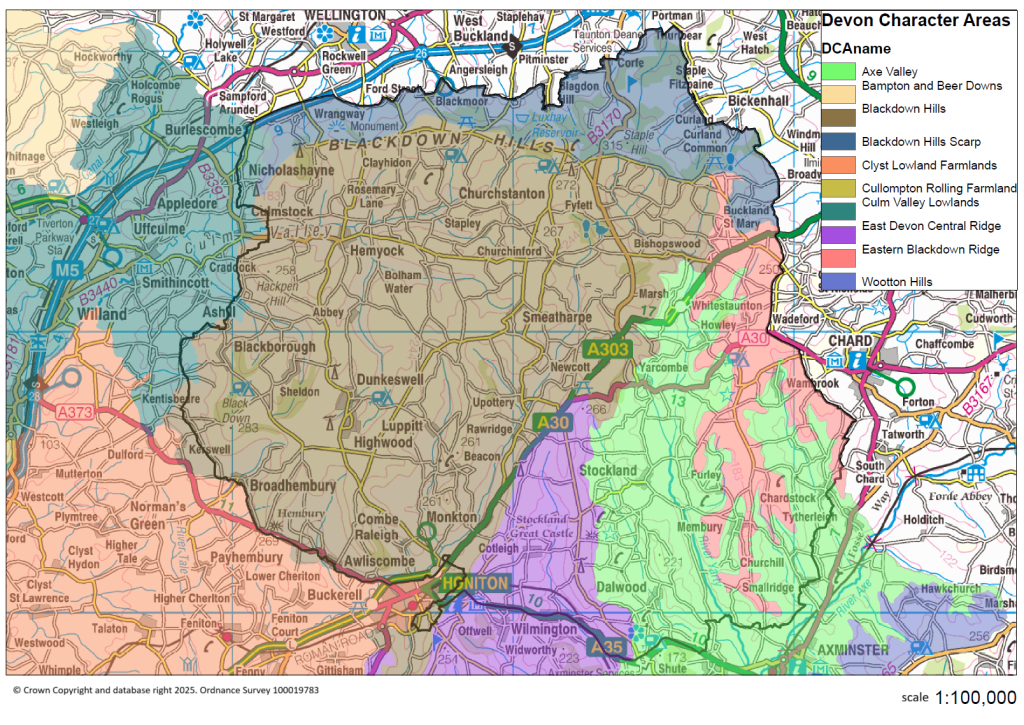
For full profiles, see www.devon.gov.uk/planning/planning-policies/landscape/devon-character-areas/east-devon-area
Blackdown Hills
This landscape at its core comprises a central plateau landscape which is elevated, exposed and open in character and which fans out into narrow ridges at its edges where it is fringed by steeply sloping wooded greensand edges and farmed slopes which descend into river valleys. The interplay of open, elevated plateau (with its regular enclosure pattern and beech hedges, outgrown beech hedges and pine shelterbelts), the steeply sloping fringes (which are cloaked in woodland), and the farmed valleys (with small scale irregular enclosures) gives this landscape its distinctiveness. The expansive plateau and prominent beech shelterbelts, in particular, distinguish this area from the East Devon Central Ridge found further south and east. In places there is a sense of bleakness about the longer views across unbroken stretches of plateau.
Distinctive Characteristics
- Elevated plateau underlain by clay-with-flints fringed by steep slopes of Upper Greensand.
- Landscape drained by streams and springs radiating out from the plateau area and draining into the Culm or Otter valley.
- Higher ground sparsely wooded with characteristic beech hedgebanks and some pine shelterbelts.
- Steep scarp slopes that are densely wooded – ancient oak with bluebells and primroses; and some conifer plantations which extend onto the ridges.
- Regular modern and Parliamentary fields of large and medium scale on the plateaux, reflecting late enclosure of common land, contrasting with smaller curving fields of medieval origin on valley slopes.
- Low narrow earthbanks with hedges on plateaux; with wider historic banks in the upper farmed valleys; and more species-diverse Devon hedges (e.g. beech, sycamore, ash, hazel and gorse) with flower, fern and moss-rich banks on lower slopes.
- Mainly pasture (often improved) and dairy farming with some mixed farming on heavy brown soils.
- Remnant areas of gorse, heathland and bracken on the plateau; ancient semi-natural and broadleaved woodlands on the scarp slopes; semi-improved and unimproved acidic and neutral grassland and springline mires (including carr woodland) occurring mainly on the scarp slope and in the upper farmed valleys.
- Bronze Age barrows in elevated positions on ridges; former castle sites in prominent locations at the ends of narrow ridges overlooking valleys; ancient settlement remains; remains of Cistercian abbey at Dunkeswell, all lending strong time-depth.
- Clustered hamlets and villages at road crossings and spring lines. Farmsteads scattered throughout, nestled in dips with beech shelterbelts.
- Straight roads with verges on narrow ridges descending abruptly and steeply to sinuous lanes defined tightly by close hedgebanks.
- Very distinctive building tradition that uses local cherts (flint-like nodules occurring occurs within greensand) with red brick detailing and slate roofs.
- Strong overarching perceptions of tranquillity and remoteness in many areas.
Special Qualities and Features
- Distinctive, unspoilt, and very exposed skylines often looking over the crowns of woodland on the steep greensand slopes with some views of the Wellington Monument in adjacent character area.
- High scenic quality reflected in the area forming part of the Blackdown Hills National Landscape.
- Outstanding views across East Devon and across the Otter and Culm valleys; northern vantage points offer extensive views across Somerset.
- Sense of isolation and remoteness, enhanced by exposure of the plateau; tranquillity provided by the dense woodland of the greensand scarps; one of the most tranquil areas in East Devon.
- Many county/local wildlife sites (CWSs) and SSSIs including ancient semi-natural woodland e.g. Bywood Copse; semi-improved and improved acidic and neutral grasslands and springline mires (e.g. Southey and Gotleigh Moors); and extensive areas of heathland and gorse scrub particularly on Blackdown and Sampford Commons.
- Prominent Bronze Age barrows on Brown Down; earthwork remains of former castles e.g. Castle Neroche, Dumpdon Camp and Hembury Fort.
- Picturesque villages with traditional buildings linked by narrow winding lanes; many listed buildings.
- Early 20th century artist Robert Bevan and the Camden Group of artists associated with Clayhidon.
Overall Landscape Strategy
To protect the interrelationship and contrasts between open plateau, wooded scarp and intimate valley farmland which underpin the high scenic quality of this area. Opportunities are sought to restore conifer plantations to broadleaves and heathland habitats, reinforcing the distinction between the landscape types that make up this character area and strengthening the network of valuable heathland habitat. Field patterns are reinforced through the restoration and management of distinctive hedgebanks and shelterbelts. Scarp woodlands are managed and valley side wetlands are expanded to help prevent downstream flooding and protect water quality. The landscape’s time-depth continues to have a strong influence, whilst opportunities for sustainable recreation and limited low-carbon development are sensitively accommodated. The open expansive views from the plateau landscape and its unfettered skylines are protected.
Blackdown Hills Scarp
This landscape forms a wide band of scarp woodlands and farmed slopes which are orientated east-west, and which face northwards over the Vale of Taunton. Historically this area has divided the counties of Somerset and Devon. This is a dramatic landscape that is very prominent, particularly in views from the north. It stands out from the land that surrounds it; and has considerable visual interest and texture due to its diverse land use and woodland cover. The Wellington Monument, a key landmark, is located on the north-facing slopes which are gently undulating, rising to Staple Hill. The western end of the scarp is most pronounced; to the east the slopes become broader and gentler. There is dense semi-natural woodland cover on the steepest slopes, along with patches of gorse and scrub. Vegetation patterns are often irregular, reflecting variations in the underlying landform, although in some areas these variations are masked by conifer plantations. The wet pastures associated with spring lines add further interest and texture to this landscape.
Distinctive Characteristics
- Steeply sloping scarp comprising unstable greensand on Keuper Marl and Lower Lias Clays on the lower slopes and valleys.
- Springs emerge from the interface of greensand and clays resulting in numerous streams flowing northwards with associated areas of mires, willow carr and rushy grassland.
- Sloping landform and indented topography as well as extensive belts of oak-ash woodland and some areas of conifer plantation lend visual enclosure.
- Woodlands separated by small fields of improved and semi-improved pasture; occasional arable land and in-field copses on the lower slopes.
- Magnificent beech avenues on parts of the escarpment crest, particularly towards its eastern end.
- Habitats that include many ancient woodland sites, areas of semi-improved and rushy grassland, and heathland commons.
- Range of historic features including the Wellington Monument, small quarries, hillforts and medieval field patterns.
- Limited settlement on steep scarp slopes; dispersed pattern of small springline villages and farmsteads with associated orchards and little to no modern development.
- Local vernacular buildings of chertstone with slate roofs.
- Roads frequently run north-south and are often narrow and incised into the landscape.
Special Qualities and Features
- Distinctive north-facing scarp marked by the Wellington Monument, lending a strong sense of place and widespread visual influence across the Vale of Taunton.
- Outstanding views northwards across the Vale of Taunton but also to Quantock Hills, Exmoor National Park and the Culm valley.
- High scenic quality reflected in the area’s inclusion in the Blackdown Hills National Landscape.
- SSSIs including ancient woodland e.g. Quants (also SAC), Prior’s Park and Adcombe Wood (providing important habitats for bats), and heathland commons e.g. Blackdown and Sampford Commons at the western end of the scarp.
- Important historic landscape around Neroche, at the eastern end of the scarp, site of an Iron Age hillfort and motte and bailey castle (Scheduled Monument), and part of a royal hunting forest in medieval times.
- Extensive areas of open access land e.g. Staple Hill and Blackdown Common.
Overall Landscape Strategy
To protect the landscape’s distinctive scarp slopes, well wooded character and iconic Wellington Monument which contributes a strong sense of place. Opportunities are sought to restore conifer plantations to broadleaves and heathland habitats and strengthening the network of valuable heathland habitats. Field patterns are reinforced through the restoration and management of distinctive hedgebanks. Scarp woodlands and beech avenues are managed; and valley side wetlands are expanded to help prevent downstream flooding and protect water quality. The landscape’s time-depth continues to have a strong influence, whilst opportunities for sustainable recreation and limited low-carbon development are sensitively accommodated. The peaceful and historic character of the area is enhanced whilst providing recreational opportunities in less prominent locations.
Eastern Blackdown Ridge
This landscape of gently undulating elevated ridge is similar in character to other Blackdown ridges comprising an open and exposed plateau landscape with regular field boundaries reflecting late enclosure of wasteland. However, it lacks the fringing wooded greensand scarp that characterises the other Blackdown ridges. Instead the edge of the ridge connects directly with the farmed slopes of the upper river valleys. Hence there is a smoother transition between exposed open upland and the valleys below, and contrasts in land form and land cover are less pronounced. This landscape has a strong time-depth reflected in its historic enclosures, archaeological sites and settlement pattern, which comprises small hamlets and dispersed farmsteads. The small villages (e.g. Buckland St Mary and Whitestaunton) are often surrounded by trees and their associated church towers act as landmarks within the open elevated landscape.
Distinctive Characteristics
- Elevated, gently undulating ridge of mudstone, sandstone and limestone fringed by upper farmed slopes.
- Limited watercourses on the plateau but occasional farm ponds, which are characteristic.
- Regular modern and Parliamentary fields of large and medium size on the ridges, reflecting late enclosure of common land.
- Contrasting smaller curving fields of medieval origin on adjacent valley slopes.
- Low narrow earthbanks with hedges on ridgetop with wider historic banks in the upper farmed valleys.
- Mainly pasture (often improved) and dairy farming with some mixed farming on heavy brown soils.
- Historic hamlets nestled into gentle folds of the landscape.
- Semi-natural habitats limited to small areas of unimproved marshy grassland and semi-improved acid grassland.
- Strong local vernacular of chert buildings with slate roofs, with more use of Hamstone detailing and local Lias than elsewhere in the Blackdown Hills.
Special Qualities and Features
- High scenic quality reflected in the area’s inclusion in the Blackdown Hills National Landscape.
- Outstanding views southwards across the Axe Valley, and eastwards across a wide panorama from the A303 at Ham.
- Bronze Age barrows; Iron Age hillforts (south-east of Four Gates and south of Howley Farm); Membury Castle; and site of Roman villa at Whitestaunton – all Scheduled Monuments.
- Intact historic hamlets centred on churches, with many listed buildings and little or no modern development, adding to local distinctiveness and sense of place.
- Flower-rich meadows.
- Strong overarching perceptions of tranquillity and remoteness in many areas.
Overall Landscape Strategy
To protect the open elevated character of the ridge and its historic hamlets surrounded by woodland and with distinctive church towers. Field patterns are reinforced through the restoration and management of distinctive hedgebanks. Small woodlands and the settings to settlements are managed and field ponds maintained. The landscape’s time-depth continues to have a strong influence, whilst opportunities for sustainable recreation and limited low-carbon development are sensitively accommodated. Opportunities are sought to remove conifer plantation and extend broadleaved woodland.
East Devon Central Ridge
(extends beyond Blackdown Hills National Landscape)
This landscape comprises a narrow, elevated, rolling ridge fringed by steep scarp slopes and upper valley farmland. The main ridge forms a distinctive spine to East Devon, fanning out into a series of narrow fingers that have distinctive southerly aspect and are flanked to the south by wooded slopes, which give way to small scale farmland in the upper and tributary valleys of the Axe and Sid. The northern finger of the ridge sits between the upper Otter valley and the Yarty valley. The river valleys drain southwards, forming steep sided and often remote-feeling valleys, whose sides are clothed with ancient oak woodlands. The Sid valley is the major landscape feature of the southern part of the area; further east the valleys are shorter, steeper and narrower. Views from the open upland ridges, particularly in the north, are extensive, often looking over the tree tops on the steep greensand scarps to other ridges beyond and into the visually strong field pattern of the valley slopes. The area is sparsely settled, with individual farmsteads and small hamlets in the valleys and vernacular buildings mainly of stone and red brick. Seen from the south, the area forms a backdrop to the valleys, separating the coastal plateau and Axe valley from the Blackdown Hills to the north.
Distinctive Characteristics
- Elevated narrow ridge with a rolling topography underlain by clay-with-flints or Upper Greensand.
- Landscape crossed by streams and springs draining into the adjacent steeply incised wooded valleys.
- Higher ground sparsely wooded with grown-out beech hedgebanks and some pine shelterbelts.
- Steep scarp slopes that are densely wooded – ancient oak with bluebells and primroses; and some conifer plantations which extend onto the ridges.
- Regular modern and Parliamentary fields of large and medium scale on the ridges, reflecting late enclosure of common land (e.g. Stockland Hill), contrasting with smaller curving fields of medieval origin on valley slopes.
- Low narrow earthbanks with hedges on the ridgetop, with wider historic banks in the upper farmed valleys and more species-diverse Devon hedges (e.g. beech, sycamore, ash, hazel and gorse) with flower, fern and moss-rich banks on lower slopes.
- Mainly pasture (often improved) and dairy farming with some mixed farming on heavy brown soils.
- Remnant areas of gorse, heathland and bracken on the ridges; ancient semi-natural and broadleaved woodlands on the scarp slopes; semi-improved and unimproved acidic and neutral grassland and springline mires occurring mainly on the scarp slope and in the upper farmed valleys.
- Bronze Age barrows in elevated positions on the ridges; hillfort sites on upper slopes of valleys; ancient settlement remains that also lend strong time-depth.
- Clustered hamlets and villages at road crossings with little 20th century development. Farmsteads scattered throughout, nestled in dips with beech shelterbelts.
- Straight roads with verges on ridges change abruptly to sinuous lanes defined tightly by close hedgebanks, with steep descents.
- Very distinctive building tradition that uses local cherts (flint-like nodules occurring occurs within greensand) with red brick detailing and slate roofs.
- Strong overarching perceptions of tranquillity and remoteness in many areas.
Special Qualities and Features
- Distinctive, unspoilt, and very exposed skylines.
- High scenic quality reflected in the north half of the area forming part of the Blackdown Hills National Landscape and the southern half part of the East Devon National Landscape.
- Outstanding views across East Devon, mainly southwards to the coast but also northwards into the Blackdowns.
- Sense of isolation, tranquillity and remoteness, enhanced by natural qualities of the rivers and scarp woodlands.
- Many County Wildlife Sites comprising ancient semi-natural woodland; semi-improved and improved acidic and neutral grasslands; springline mires; and extensive areas of heathland and gorse scrub particularly on Gittisham Hill and Broad Down and Dumpdon Hill.
- Prominent Bronze Age barrows on Gittisham Hill and Farway Hill; earthwork remains of former castles e.g. Stockland Little Castle, Stockland Great Castle and Farway Castle hillforts.
- Combe House Registered Park and Garden, including historic wood pasture and parkland.
- Picturesque villages with traditional buildings linked by narrow winding lanes crossing historic stone bridges; many listed buildings.
Overall Landscape Strategy
To protect the distinctive and highly scenic interrelationship of narrow ridge, wooded scarp and intimate upland valley. Opportunities are sought to restore conifer plantations to broadleaved and heathland habitats reinforcing the distinction between the landscape types that make up this area and strengthening the network of valuable heathland habitat. Field patterns are reinforced through the restoration and management of distinctive hedgebanks. Scarp woodlands are managed and valley side wetlands expanded to help prevent downstream flooding and protect water quality. The landscape’s time-depth continues to have a strong influence, while opportunities for sustainable recreation and limited low-carbon development are sensitively accommodated. The peaceful and historic character of the valley settlements is enhanced whilst providing recreational spaces in less prominent locations.
Axe Valley
(extends beyond Blackdown Hills National Landscape)
This is a broad, distinctive lowland river valley landscape with a wide floodplain, tightly meandering river course and valley sides which are formed by surrounding higher land. The valley sides have a strong hedgerow pattern with hedgerow trees coupled with small broadleaved woods and occasional farm orchards which give rise to a generally wooded character overall. Land use is mainly pastoral set within small fields in the upper tributary valleys, with larger fields and some arable within the main Axe Valley. The open valley floor and relatively loosely defined valley sides make the character of this valley rare in a Devon context. The tributary valleys of the Coly and Yarty are narrower and therefore more enclosed and intimate although they also have notable floodplains. Drainage channels are a feature, particularly in the central part of this character area, and settlement is focused on the river corridor at key crossing points just above the flood risk areas. During the autumn, winter and spring this area has a ‘watery’ ephemeral and timeless quality. Towards its southern end the valley is closely flanked by steep wooded greensand scarp slopes and assumes a more tidal character where it cuts through the coastal plateau to the sea. In contrast, moving northwards, there is a more gradual transition from river valley to upland open ridge.
Distinctive Characteristics
- Geology comprises underlying mudstone, siltstone, limestone and sandstone bedrock on the valley sides with sand and gravel alluvial deposits within the floodplains.
- The middle and lower reaches of the valley floor are typically broad and open while further north the valley floor narrows becoming more undulating.
- Distinctive valley of the River Axe and its tributaries the Coly and Yarty which penetrate into the surrounding greensand ridges particularly to the north.
- Meandering course of the river Axe and network of drainage ditches are features of the floodplain and maritime tidal marsh at the estuary and coast.
- Strong hedgerow pattern with hedgerow trees coupled with small broadleaved woods, occasional farm orchards, and carr woodlands along tributary rivers particularly north of Axminster, give rise to a generally wooded character overall.
- Mainly pastoral landscape within small fields in the upper tributary valleys; larger fields within the main Axe Valley and some arable farming on the floodplains and lower slopes.
- Semi-natural habitats include water meadows, unimproved river banks, carr woodlands and species-rich pastures on the valley sides.
- Many historic features including the Fosse Way Roman road and Roman town of Axminster, ancient lanes and greenways and the historic ruins of Colcombe Castle, Newenham Abbey and Second World War defences.
- Historic settlements sited at old river crossing points just above the floodplain including Axminster, Seaton and Colyton and the villages of Whitford, Maidenhayne, Musbury, Kingsdon and Colyford
- Elsewhere, a dispersed pattern of farmsteads scattered across the valley sides, often nestling next to springlines.
- Local vernacular includes cob and thatch buildings.
- Generally open character with views across valley floor to gentle valley sides with more intimate, enclosed tributary valleys.
Special Qualities and Features
- Nationally valued landscape of high scenic quality, much of the area being National Landscape (northern section part of the Blackdown Hills National Landscape and southern section part of East Devon National Landscape).
- High degree of tranquillity and remoteness in the tributary valleys.
- River Axe is SSSI and SAC along its entire length; two further large SSSI sites on the valley floor (wet grassland).
- Estuary habitats valued for their saltmarshes and mudflats (Seaton Marshes CWS) and waders.
- Ancient woodlands, many of which are County Wildlife Sites, on the valley sides particularly north of Axminster.
- Regionally Important Geological site on former sand and gravel workings at Kilmington (terrace gravels containing exotic pebbles).
- 17th and 18th country houses including Stedcombe House; and Woodend Park which contains notable veteran trees of national importance for their wood decay invertebrates and lichens.
- Vernacular buildings of cob and thatch and village church towers that add to the picturesque qualities of the area.
- Cultural associations with WG Hoskins who described Colyton as ‘singularly beautiful, with rolling green hills and deep combes’.
- Second World War pillboxes within flood plain form a distinctive landscape feature.
- Important area for recreation including walking and horse riding – area includes the East Devon Way long distance footpath which runs through the valley.
Overall Landscape Strategy
To protect the landscape’s watery and open character, historic settlements and pastoral valley sides and its important picturesque qualities. Opportunities to manage and extend areas of water meadow and distinctive features such as traditional orchards are sought. Views to church towers are retained along with the historic character and form of the villages; with any new development or infrastructure carefully sited and sensitively integrated.
Culm Valley Lowlands
(Blackdown Hills National Landscape is only a very small peripheral part)
The colourful patchwork of fields, thick hedgerows and distinctive red soils visible in this area combine to form a quintessential ‘Devon’ scene. The area is the ‘gateway’ into Devon when viewed from the major transport corridors (road and rail) which pass through it. Its sense of history as a transport corridor is apparent in the Grand Western Canal, which flows serenely through the area, crossed by distinctive bridges. Despite the presence of busy transport routes and several large settlements, the valley of the River Culm retains a peaceful atmosphere, with the tree-lined river meandering through a wide floodplain.
Distinctive Characteristics
- Varied underlying geology, comprising red Permian sandstones in the western part of the area, Permian mudstones and Triassic sandstones in the central part, and Triassic mudstones in the eastern part, with localised limestone outcrops elsewhere.
- Relatively low and gently undulating landform, separating the wide, flat-bottomed valleys of the rivers Culm, Tone and Lowman.
- Relatively few woodlands, but abundant hedgerows, hedgerow trees and riparian vegetation, giving the landscape a well-treed appearance.
- Predominantly pastoral use on medium-quality soils in the east of the area; more widespread arable cultivation in the western part of the area where soils are more fertile.
- Field boundaries consisting of thick hedgerows with mature hedgerow trees including numerous oaks.
- Fields generally semi-regular in shape, with surviving areas of medieval fields and post-medieval ‘Barton’ fields, particularly west of Halberton, and in the northern and eastern parts of the area.
- Valley-bottom wetlands and occasional blocks of woodland and surviving heathland; hedgerows and verges that also provide wildlife habitats and corridors.
- Numerous surviving orchards, particularly around Holcombe Rogus and Halberton, which are characteristic landscape features and add biodiversity value.
- Archaeological and historic sites from many periods, including prehistoric barrows, Roman forts, and medieval buildings (e.g. village churches and Cannonsleigh Abbey) that lend a sense of time-depth.
- Parkland estates locally influencing landscape character.
- Grand Western Canal and other historic river features including weirs, bridges and large mill buildings.
- Relatively densely settled with towns and large villages along the rivers (Cullompton, Willand, Uffculme, Sampford Peverell) and near Tiverton; smaller nucleated villages and scattered farms throughout.
- Local vernacular buildings of local stone or white-rendered cob, with slate or thatched roofs.
- Extensive modern development around the peripheries of larger settlements, including industrial development associated with transport routes.
- Extractive industries, including stone quarries and sand and gravel workings.
- An important transport corridor between Devon and Somerset, containing historic and modern routes including the Grand Western Canal, the London-Exeter railway line, the A38 and the M5.
- A network of steep, narrow lanes enclosed between high hedgebanks connecting villages and farms.
- By Devon standards, a ‘busy’ landscape but with some parts retaining a more remote and peaceful feel, particularly in the northern part of the area.
- Unexpected long views e.g. to the Sidmouth Gap from the Swan’s Neck on the Grand Western Canal near Halberton.
Special Qualities and Features
- A very important ‘gateway’ into Devon for people arriving by car on the M5 and A38, and also by train.
- A landscape contributing to the setting of several settlements including Tiverton and Cullompton.
- Several SSSIs, including geological exposures and fossil-bearing rocks; Maiden Down lowland heath, and Tidcombe Lane fen, a wetland site containing over 100 species of flowering plants.
- CWSs including small blocks of ancient woodland and grassland sites.
- Several Scheduled Monuments – including prehistoric barrows, Roman forts, Roman camps and Cannonsleigh Abbey – indicating the importance of this area as a routeway and for settlement for thousands of years.
- Bridwell Park (west of Uffculme) listed grade II on the Register of Historic Parks and Gardens for its late 18th century park and pleasure grounds, including woodland and lake with views across the Culm valley.
- Numerous Conservation Areas (reflecting the dense settlement) including historic cores of Burlescombe, Holcombe Rogus, Halberton, Kentisbeare, Sampford Peverell, Uffculme, Smithincott and Ashill.
- Grand Western Canal from Taunton to Tiverton (opened 1838); associated industrial archaeology, LNR and linear Country Park providing historic, wildlife and recreational interest.
- Grand Western Canal Towpath and National Cycle Route 3 as well as small areas of common land (such as Maiden Down) with public access.
Overall Landscape Strategy
To protect the area’s characteristic Devon agricultural landscape and enhance its role as a gateway into Devon. Agricultural land use is encouraged, and associated features such as hedgerows are well-maintained. The biodiversity of agricultural land is increased. Development in the form of settlements and transport corridors is sensitively accommodated. Links between settlements and the countryside are encouraged, and the recreational, historic and wildlife values of the river valleys are enhanced.
Footer Navigation
Widget


Widget
