
Historic environment report
The historic environment of the Blackdown Hills.
By Bill Horner, Devon County Archaeologist.
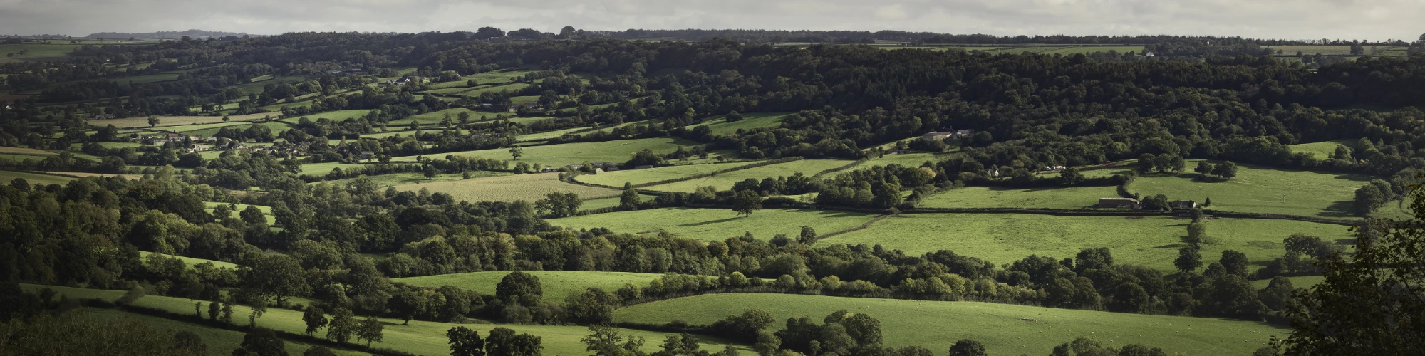
The Blackdown Hills Area of Outstanding Natural Beauty is rich in historic environment interest, including historic and archaeological sites and buildings and settlements of historic interest. In all 4,058 sites and buildings of archaeological and historic interest are recorded within the AONB on the Devon and Somerset Historic Environment Records (HERs) and there are 767 Listed Buildings of architectural and historic interest. However, the wider landscape of the AONB is also full of historic character. This landscape has been formed by centuries of human activity and management, creating an intricate pattern of fields, heaths, woods, lanes, hamlets and villages. This ancient managed landscape contributes greatly to the unique
character of the Blackdown Hills AONB.
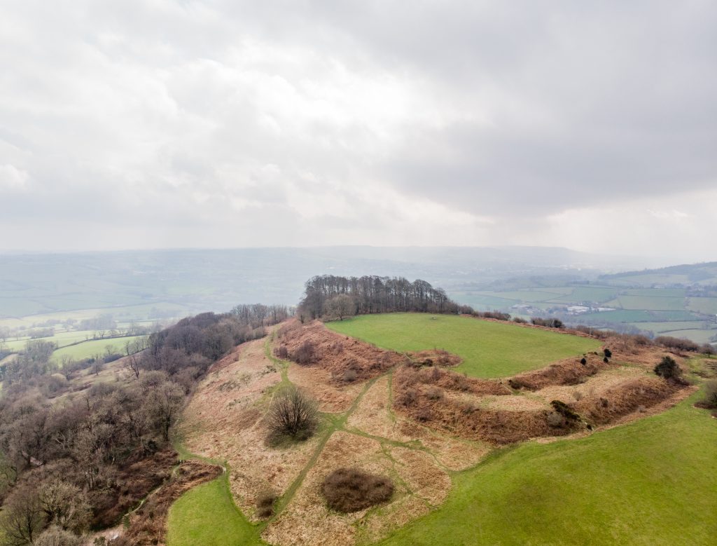
The AONB contains significant concentrations of early prehistoric evidence. The density of flint and chert tools found particularly in the parishes of Stockland and Membury indicate that this area was an important source of food and raw materials for Mesolithic people. The presence of Neolithic causewayed enclosures at Hembury and Membury and flint scatters of this date, including finds of flint axes, indicate continuing settlement and exploitation of local resources. There is also an important and visible range of later prehistoric evidence. The Bronze Age round barrow cemeteries on Brown Down and Dunkeswell Turbary and many isolated barrows on the greensand ridge tops are distinctive landmarks. Some of the most impressive sites within the AONB are the large Iron Age hillforts that make great advantage of the local topography. Hembury is one of Devon’s most striking hillforts, with other examples at Dumpdon, Stockland and Membury, with Knapp and Howley on the Somerset side. Of the 26 Scheduled Ancient Monuments within the AONB, 10 are Bronze Age barrows or barrow cemeteries and 7 are hillforts.
A Roman fort has been identified within the hillfort at Hembury. A later civilian villa or at least a ‘Romanised’ farm with a luxurious bath-house is known at Whitestaunton and has been Scheduled as an Ancient Monument. Other Romanised farms existed at Membury and probably Woonton in Chardstock. Iron working was an important industry in the Roman period and continued into the Middle Ages. A cratered landscape, created by opencast iron working on the plateau top, can still be seen around North Hill on the west side of the AONB and heaps of iron tap slag and ‘cinder’ place names, evidence of smelting, are widespread across the area.
The spring-line mires of the Blackdown Hills are proving to be an important resource for reconstructing past environments. Peat deposits from these sites can date back to prehistoric times and the preserved pollen records changes from woodland to pastoral and arable farming. Key sites of the medieval period include Castle Neroche, Dunkeswell Abbey and Hemyock Castle. Castle Neroche in its striking location on the northern escarpment overlooking the Vale of Taunton is an early Norman earthwork castle built on an earlier Saxon and possibly Iron Age defended site. Hemyock Castle is a good example of a fortified manor house of the later medieval period. Dunkeswell Abbey was founded in the 13th century and is likely to have had a significant influence on the wider landscape through its grange farms and probable involvement in iron production. All three sites are Scheduled Ancient Monuments.
For most of its history the Blackdown Hills AONB has been reliant on agriculture, with the distinctive patterns of fields and many of the dispersed farmsteads and hamlets present today originating during the medieval period. A notably high proportion of the landscape has been identified as of medieval origin by historic landscape characterisation projects in Devon and Somerset. The Culm valley between Hemyock and Culmstock contains a concentration of enclosed former medieval strip fields, but evidence that such systems were once widespread is particularly well preserved throughout the AONB in characteristic enclosure patterns and in terraced strips on now marginal grassland. Irregular fields and massive hedges in the valleys, such as around Clayhidon, represent land taken directly into cultivation from woodland in the medieval period.
The AONB contains a large number of deserted or shrunken medieval and post-medieval settlements. These reflect periods of agricultural prosperity when areas of marginal agricultural value came into cultivation. The earthworks of such settlements can be seen at Jacob’s City in Clayhidon and Luxon Hill in Yarcombe. The deserted settlement at Weston Farm, Wambrook, may have been cleared to make way for sheep farming in the 15th or 16th century. Some former hamlets continued as individual farms into the 19th century, when a further agricultural downturn resulted in final abandonment.
Ancient woodland, perhaps surviving from the medieval period, is still well represented within the AONB, particularly on the northern escarpment. The managed woodland of the Neroche Forest was used by many parishes in the area and although it was enclosed into fields in the 1830’s traces of woodbanks survive.
Modern, Parliamentary Inclosure of former commons on the plateau tops in the 19th century has also created distinctive landscapes of large regular fields with straight roads and Beech hedges, such as at Stockland Hill. Beacon Hill in Upottery parish was the last area of England to be enclosed in this way in 1874.
The AONB has a distinctive vernacular architecture. Local materials such as chert, cob, thatch and clay tiles are used extensively as well as local limestone and Beer stone. The AONB is exceptional because of the large number of standing houses of late medieval date. Examples include Membury Court, Whitestaunton Manor and Lower Lye at Stockland. Many are Grade II* Listed Buildings and contain particularly fine woodwork in the form of screens, ceilings and jetties; evidence of the transition from open hall houses to more modern forms. Most farmsteads and hamlets are sited in the sheltered valleys, often terraced into the hillslope. Of the main settlements nine are Conservation Areas. A particularly large number of medieval houses can be seen in Broadhembury. Villages are often sites at river crossings and crossroads in the valley floors and are generally nucleated around the parish church, such as Pitminster, Churchinford and Stockland. Topography often influences settlement form as at Membury where the village straggles along the valley and Blackborough where the hamlet follows the escarpment.
In addition to ironworking, geology has had a strong influence on the industrial archaeology, landscape and architecture of the Blackdown Hills. Mining of a hard seam of stone within the greensand for whetstone production reached its heyday in the 18th and 19th centuries and the scars left by collapsed tunnels can still be seen on the western escarpment, particularly around Kentisbeare and Broadhembury.
The exploitation of stone, marl, sand, gravel and clay for agriculture local building and hedging and pottery production have left a legacy of pits across the AONB. A medieval pottery industry based on chert-tempered local clays once existed in the Membury/Axminster area and a pottery production site of the post-medieval period has been found in Hemyock. There are significant numbers of largely 18th and 19th century limekilns sited within the AONB, particularly on the Lias Limestone of the Bishopswood area and adjacent to the chalklands of Wambrook parish. Chert from the upper greensand is extensively used in buildings and walls across the AONB. Limestone was quarried for building stone at Tolcis from the medieval period onwards.
Although formal landscapes, parks and gardens are not particularly widespread within the AONB, those that there are do make a particular contribution to the landscape. The Wellington Monument of 1817-54 is an iconic feature, defining the north-west escarpment. Although the Victorian manor house at Upottery has gone, its parkland remains as well as a lodge, stables and a school and estate housing in the village.
The AONB also contains important evidence from the Second World War that has left a visible impact on the landscape. Three airfields were constructed, Culmhead (Trickey Warren), Dunkeswell and Upottery (Smeatharpe). As well as the run-ways, a wide range of structures survive at all three sites, including defensive pillboxes, aircraft dispersal pens, technical and domestic buildings. Their historic significance is being increasingly recognised locally as well as through national designation of components as Scheduled Monuments and Listed Buildings.
Footer Navigation
Widget


Widget
